
6.4.2: Volcanoes
- Page ID
- 69412

\( \newcommand{\vecs}[1]{\overset { \scriptstyle \rightharpoonup} {\mathbf{#1}} } \)
\( \newcommand{\vecd}[1]{\overset{-\!-\!\rightharpoonup}{\vphantom{a}\smash {#1}}} \)
\( \newcommand{\dsum}{\displaystyle\sum\limits} \)
\( \newcommand{\dint}{\displaystyle\int\limits} \)
\( \newcommand{\dlim}{\displaystyle\lim\limits} \)
\( \newcommand{\id}{\mathrm{id}}\) \( \newcommand{\Span}{\mathrm{span}}\)
( \newcommand{\kernel}{\mathrm{null}\,}\) \( \newcommand{\range}{\mathrm{range}\,}\)
\( \newcommand{\RealPart}{\mathrm{Re}}\) \( \newcommand{\ImaginaryPart}{\mathrm{Im}}\)
\( \newcommand{\Argument}{\mathrm{Arg}}\) \( \newcommand{\norm}[1]{\| #1 \|}\)
\( \newcommand{\inner}[2]{\langle #1, #2 \rangle}\)
\( \newcommand{\Span}{\mathrm{span}}\)
\( \newcommand{\id}{\mathrm{id}}\)
\( \newcommand{\Span}{\mathrm{span}}\)
\( \newcommand{\kernel}{\mathrm{null}\,}\)
\( \newcommand{\range}{\mathrm{range}\,}\)
\( \newcommand{\RealPart}{\mathrm{Re}}\)
\( \newcommand{\ImaginaryPart}{\mathrm{Im}}\)
\( \newcommand{\Argument}{\mathrm{Arg}}\)
\( \newcommand{\norm}[1]{\| #1 \|}\)
\( \newcommand{\inner}[2]{\langle #1, #2 \rangle}\)
\( \newcommand{\Span}{\mathrm{span}}\) \( \newcommand{\AA}{\unicode[.8,0]{x212B}}\)
\( \newcommand{\vectorA}[1]{\vec{#1}} % arrow\)
\( \newcommand{\vectorAt}[1]{\vec{\text{#1}}} % arrow\)
\( \newcommand{\vectorB}[1]{\overset { \scriptstyle \rightharpoonup} {\mathbf{#1}} } \)
\( \newcommand{\vectorC}[1]{\textbf{#1}} \)
\( \newcommand{\vectorD}[1]{\overrightarrow{#1}} \)
\( \newcommand{\vectorDt}[1]{\overrightarrow{\text{#1}}} \)
\( \newcommand{\vectE}[1]{\overset{-\!-\!\rightharpoonup}{\vphantom{a}\smash{\mathbf {#1}}}} \)
\( \newcommand{\vecs}[1]{\overset { \scriptstyle \rightharpoonup} {\mathbf{#1}} } \)
\(\newcommand{\longvect}{\overrightarrow}\)
\( \newcommand{\vecd}[1]{\overset{-\!-\!\rightharpoonup}{\vphantom{a}\smash {#1}}} \)
\(\newcommand{\avec}{\mathbf a}\) \(\newcommand{\bvec}{\mathbf b}\) \(\newcommand{\cvec}{\mathbf c}\) \(\newcommand{\dvec}{\mathbf d}\) \(\newcommand{\dtil}{\widetilde{\mathbf d}}\) \(\newcommand{\evec}{\mathbf e}\) \(\newcommand{\fvec}{\mathbf f}\) \(\newcommand{\nvec}{\mathbf n}\) \(\newcommand{\pvec}{\mathbf p}\) \(\newcommand{\qvec}{\mathbf q}\) \(\newcommand{\svec}{\mathbf s}\) \(\newcommand{\tvec}{\mathbf t}\) \(\newcommand{\uvec}{\mathbf u}\) \(\newcommand{\vvec}{\mathbf v}\) \(\newcommand{\wvec}{\mathbf w}\) \(\newcommand{\xvec}{\mathbf x}\) \(\newcommand{\yvec}{\mathbf y}\) \(\newcommand{\zvec}{\mathbf z}\) \(\newcommand{\rvec}{\mathbf r}\) \(\newcommand{\mvec}{\mathbf m}\) \(\newcommand{\zerovec}{\mathbf 0}\) \(\newcommand{\onevec}{\mathbf 1}\) \(\newcommand{\real}{\mathbb R}\) \(\newcommand{\twovec}[2]{\left[\begin{array}{r}#1 \\ #2 \end{array}\right]}\) \(\newcommand{\ctwovec}[2]{\left[\begin{array}{c}#1 \\ #2 \end{array}\right]}\) \(\newcommand{\threevec}[3]{\left[\begin{array}{r}#1 \\ #2 \\ #3 \end{array}\right]}\) \(\newcommand{\cthreevec}[3]{\left[\begin{array}{c}#1 \\ #2 \\ #3 \end{array}\right]}\) \(\newcommand{\fourvec}[4]{\left[\begin{array}{r}#1 \\ #2 \\ #3 \\ #4 \end{array}\right]}\) \(\newcommand{\cfourvec}[4]{\left[\begin{array}{c}#1 \\ #2 \\ #3 \\ #4 \end{array}\right]}\) \(\newcommand{\fivevec}[5]{\left[\begin{array}{r}#1 \\ #2 \\ #3 \\ #4 \\ #5 \\ \end{array}\right]}\) \(\newcommand{\cfivevec}[5]{\left[\begin{array}{c}#1 \\ #2 \\ #3 \\ #4 \\ #5 \\ \end{array}\right]}\) \(\newcommand{\mattwo}[4]{\left[\begin{array}{rr}#1 \amp #2 \\ #3 \amp #4 \\ \end{array}\right]}\) \(\newcommand{\laspan}[1]{\text{Span}\{#1\}}\) \(\newcommand{\bcal}{\cal B}\) \(\newcommand{\ccal}{\cal C}\) \(\newcommand{\scal}{\cal S}\) \(\newcommand{\wcal}{\cal W}\) \(\newcommand{\ecal}{\cal E}\) \(\newcommand{\coords}[2]{\left\{#1\right\}_{#2}}\) \(\newcommand{\gray}[1]{\color{gray}{#1}}\) \(\newcommand{\lgray}[1]{\color{lightgray}{#1}}\) \(\newcommand{\rank}{\operatorname{rank}}\) \(\newcommand{\row}{\text{Row}}\) \(\newcommand{\col}{\text{Col}}\) \(\renewcommand{\row}{\text{Row}}\) \(\newcommand{\nul}{\text{Nul}}\) \(\newcommand{\var}{\text{Var}}\) \(\newcommand{\corr}{\text{corr}}\) \(\newcommand{\len}[1]{\left|#1\right|}\) \(\newcommand{\bbar}{\overline{\bvec}}\) \(\newcommand{\bhat}{\widehat{\bvec}}\) \(\newcommand{\bperp}{\bvec^\perp}\) \(\newcommand{\xhat}{\widehat{\xvec}}\) \(\newcommand{\vhat}{\widehat{\vvec}}\) \(\newcommand{\uhat}{\widehat{\uvec}}\) \(\newcommand{\what}{\widehat{\wvec}}\) \(\newcommand{\Sighat}{\widehat{\Sigma}}\) \(\newcommand{\lt}{<}\) \(\newcommand{\gt}{>}\) \(\newcommand{\amp}{&}\) \(\definecolor{fillinmathshade}{gray}{0.9}\)A volcano is any location where magma comes to the surface, or has done so within the past several million years (Figure \(\PageIndex{1}\)). This can include eruptions on the ocean floor (or even under the water of lake), where they are called subaqueous eruptions, or on land, where they are called subaerial eruptions. Volcanoes commonly occur near plate boundaries where the motion of the plates has created cracks in the lithosphere through which the magma can flow. About eighty percent of volcanoes occur at convergent plate boundaries where subducted material melts and rises through cracks in the crust. Not all volcanic eruptions produce the volcanic mountains with which we are familiar; in fact most of Earth’s volcanism takes place along the spreading ridges on the sea floor and does not produce volcanic mountains at all — not even sea-floor mountains.
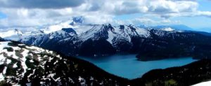
Figure \(\PageIndex{1}\): Mt. Garibaldi (background left, looking from the north) with Garibaldi Lake in the foreground. Mt. Garibaldi, near Squamish B.C., is one of Canada’s tallest (2,678 m) and most recently active volcanoes. [SE photo] The volcanic peak in the centre is Mt. Price and the dark flat–topped peak is The Table. All three of these volcanoes were active during the last glaciation. Mt. Garibaldi last erupted approximately 10,000 years ago. © Steven Earle. CC BY
The study of volcanoes is critical to our understanding of the geological evolution of Earth, and to our understanding of significant changes in climate. But, most important of all, understanding volcanic eruptions allows us to save lives and property. Over the past few decades, volcanologists have made great strides in their ability to forecast volcanic eruptions and predict the consequences — this has already saved thousands of lives.
The largest eruptions can literally explode a volcanic mountain, ejecting immense quantities of material into the environment and causing enormous damage and loss of life. For example, an eruption of Mount Vesuvius in the year 79 CE (Common Era) buried the Roman city of Pompeii, killing almost all of its inhabitants. A 1902 explosion of Mont Pelée on the Caribbean island of Martinique killed 30,000 people. Another famous Indonesian eruption was that of Krakatau in the Sunda Strait in 1883, which ejected 18-21 km3 of material as high as 50-80 km into the atmosphere. The 30-m tsunami associated with this eruption killed about 36,000 people in coastal villages.
The greatest eruption of modern times was that of Tambora, a volcano in Indonesia that exploded in 1815 and blew more than 300 km3 of material into the atmosphere (including the top 1,300 m of the mountain). Some of the finer particulates of this massive eruption were blown into the upper atmosphere (the stratosphere), causing an increase in Earth’s reflectivity that resulted in global cooling. The year 1816 became known as the “year without a summer” in Europe and North America because of its unusually cool and wet weather, including frost and snowfall during the summer months.
Large volcanic eruptions can also disturb great expanses of forest and other ecosystems. For instance, the 1980 explosion of Mount St. Helen’s in the state of Washington blew down about 21,000 hectares of coniferous forest and otherwise damaged another 40,000 ha. Mudslides also devastated large areas, and a vast region was covered by particulate debris (known as tephra) that settled from the atmosphere.
Some volcanoes produce chronic lava flows and venting of gases. These volcanoes tend to form distinctive, cone-shaped mountains from their accumulated lava, which solidifies into finely crystalline, glassy rocks. An active example of this spectacular process is Mount Kilauea in Hawaii, which sometimes erupts continuously for years. The slowly flowing lava from these volcanoes can destroy buildings and vegetation but is not otherwise dangerous because people and animals can avoid the molten streams.
Types of Volcanoes
Volcanoes can be classified according to the type and form of their ejecta. The basic types are: composite volcanoes, shield volcanoes, cinder cones, and lava domes. Composite volcanoes are steep-sided, symmetrical cones built of multiple layers of viscous lava and ash. Most composite volcanoes have a crater at the summit which contains the central vent. Lavas flow from breaks in the crater wall or from cracks on the flanks of the cone. Mt Fuji in Japan and Mt Ranier in Washington are examples of composite volcanoes.
Shield volcanoes are built almost entirely of highly fluid (low viscosity) lava flows. They form slowly from numerous flows that spread out over a wide area from a central vent. The resultant structure is a broad, gently sloping cone with a profile like a warrior’s shield. Mt Kilauea in Hawaii is an example of a shield volcano.
Cinder cones are the simplest type of volcano. They form when lava blown violently into the area breaks into small fragments that solidify and fall as cinders. A steep-sided cone shape is formed around the vent, with a crater at the summit. Sunset Crater in Arizona is a cinder cone that formed less than a thousand years ago, disrupting the lives of the native inhabitants of the region.
Lava domes are formed when highly viscous lava is extruded from a vent and forms a rounded, steep-sided dome. The lava piles up around and on the vent instead of flowing away, mostly growing by expansion from within. Lava domes commonly occur within the craters or on the flanks of composite volcanoes.
Volcanic Hazards
There are two classes of volcanic hazards, direct and indirect. Direct hazards are forces that directly kill or injure people, or destroy property or wildlife habitat. Indirect hazards are volcanism-induced environmental changes that lead to distress, famine, or habitat degradation. It is estimated that indirect effects of volcanism have accounted for approximately 8 million deaths during historical times, while direct effects have accounted for fewer than 200,000, or 2.5% of the total. Some of the more important types of volcanic hazards are summarized in Table \(\PageIndex{1}\).
| [Skip Table] | ||
| Type | Description | Risk |
|---|---|---|
| Tephra emissions | Small particles of volcanic rock emitted into the atmosphere |
|
| Gas emissions | The emission of gases before, during, and after an eruption |
|
| Pyroclastic density current | A very hot (several 100°C) mixture of gases and volcanic fragments (tephra) that flows rapidly (up to 100s of kilometers per hour (km/h)) down the side of a volcano | Extreme hazard — destroys anything in the way |
| Pyroclastic fall | Vertical fall of tephra in the area surrounding an eruption |
|
| Lahar | A flow of mud and debris down a channel leading away from a volcano, triggered either by an eruption or a severe rain event | Severe risk of destruction for anything within the channel—lahar mud flows can move at 10s of km/h |
| Sector collapse/ debris avalanche | The failure of part of a volcano, either due to an eruption or for some other reason, leading to the failure of a large portion of the volcano | Severe risk of destruction for anything in the path of the debris avalanche |
| Lava flow | The flow of lava away from a volcanic vent | People and infrastructure at risk, but lava flows tend to be slow (less than km/h) and are relatively easy to avoid |
Volcanic Gas and Tephra Emissions
Large volumes of tephra (rock fragments, mostly pumice) and gases are emitted during major plinian eruptions (large explosive eruptions with hot gas and tephra columns extending into the stratosphere) at composite volcanoes, and a large volume of gas is released during some very high-volume effusive eruptions. One of the major effects is cooling of the climate by 1° to 2°C for several months to a few years because the dust particles and tiny droplets and particles of sulfur compounds block the sun. The last significant event of this type was in 1991 and 1992 following the large eruption of Mount Pinatubo in the Philippines. A temperature decrease of 1° to 2°C may not seem like very much, but that is the global average amount of cooling, and cooling was much more severe in some regions and at some times.
Over an eight-month period in 1783 and 1784, a massive effusive eruption took place at the Laki volcano in Iceland. Although there was relatively little volcanic ash involved, a massive amount of sulfur dioxide was released into the atmosphere, along with a significant volume of hydrofluoric acid (HF). The sulphate aerosols that formed in the atmosphere led to dramatic cooling in the northern hemisphere. There were serious crop failures in Europe and North America, and a total of 6 million people are estimated to have died from famine and respiratory complications. In Iceland, poisoning from the HF resulted in the death of 80% of sheep, 50% of cattle, and the ensuing famine, along with HF poisoning, resulted in more than 10,000 human deaths—about 25% of the population.
Volcanic ash can also have serious implications for aircraft because it can destroy jet engines. For example, over 5 million airline passengers had their travel disrupted by the 2010 Eyjafjallajökull volcanic eruption in Iceland.
Pyroclastic Density Currents
In a typical explosive eruption at a composite volcano, the tephra and gases are ejected with explosive force and are hot enough to be forced high up into the atmosphere. As the eruption proceeds, and the amount of gas in the rising magma starts to decrease, parts will become heavier than air, and they can then flow downward along the flanks of the volcano (Figure \(\PageIndex{2}\)). As they descend, they cool more and flow faster, reaching speeds up to several hundred kilometers per hour. A pyroclastic density current (PDC) consists of tephra ranging in size from boulders to microscopic shards of glass (made up of the edges and junctions of the bubbles of shattered pumice), plus gases (dominated by water vapor, but also including other gases). The temperature of this material can be as high as 1000°C. Among the most famous PDCs are the one that destroyed Pompeii in the year 79 CE, killing an estimated 18,000 people, and the one that destroyed the town of St. Pierre, Martinique, in 1902, killing an estimated 30,000.
The buoyant upper parts of pyroclastic density currents can flow over water, in some cases for several kilometers. The 1902 St. Pierre PDC flowed out into the city’s harbour and destroyed several wooden ships anchored there.
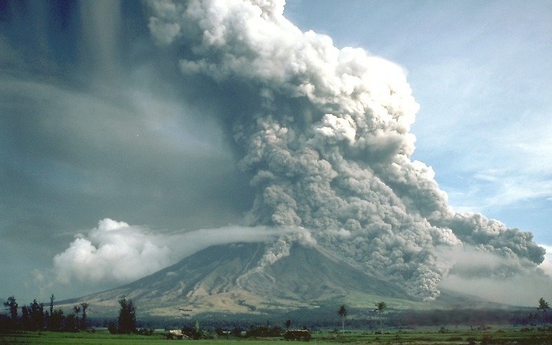
Source: “Pyroclastic flows at Mayon Volcano” by USGS. Public domain.
Pyroclastic Fall
Most of the tephra from an explosive eruption ascends high into the atmosphere, and some of it is distributed around Earth by high-altitude winds. The larger components (larger than 0.1 mm) tend to fall relatively close to the volcano, and the amount produced by large eruptions can cause serious damage and casualties. The large 1991 eruption of Mount Pinatubo in the Philippines resulted in the accumulation of tens of centimeters of ash in fields and on rooftops in the surrounding populated region. Heavy typhoon rains that hit the island at the same time added to the weight of the tephra, leading to the collapse of thousands of roofs and to at least 300 of the 700 deaths attributed to the eruption.
Lahar
A lahar is any mudflow or debris flow that is related to a volcano. Most are caused by melting snow and ice during an eruption, as was the case with the lahar that destroyed the Colombian town of Armero in 1985 (described earlier). Lahars can also happen when there is no volcanic eruption, and one of the reasons is that, as we’ve seen, composite volcanoes tend to be weak and easily eroded.
In October 1998, category 5 hurricane Mitch slammed into the coast of central America. Damage was extensive and 19,000 people died, not so much because of high winds but because of intense rainfall—some regions received almost 2 m of rain over a few days! Mudflows and debris flows occurred in many areas, especially in Honduras and Nicaragua. An example is at the Casita Volcano in Nicaragua, where the heavy rains weakened rock and volcanic debris on the upper slopes, resulting in a debris flow that rapidly built in volume as it raced down the steep slope, and then ripped through the towns of El Porvenir and Rolando Rodriguez killing more than 2,000 people (Figure \(\PageIndex{3}\)). El Porvenir and Rolando Rodriguez were new towns that had been built without planning approval in an area that was known to be at risk of lahars.
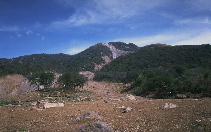
Source: “Casita Volcano” by USGS. Public domain.
Sector Collapse and Debris Avalanche
In the context of volcanoes, sector collapse or flank collapse is the catastrophic failure of a significant part of an existing volcano, creating a large debris avalanche. This hazard was first recognized with the failure of the north side of Mount St. Helens immediately prior to the large eruption on May 18, 1980. In the weeks before the eruption a large bulge had formed on the side of the volcano, the result of magma transfer from depth into a satellite magma body within the mountain itself. Early on the morning of May 18, a moderate earthquake struck nearby; this is thought to have destabilized the bulge, leading to Earth’s largest ever observed slope failure. The failure of this part of the volcano exposed the underlying satellite magma chamber, causing it to explode sideways, which then exposed the conduit leading to the magma chamber below. The resulting plinian eruption—with a 24 kilometre high eruption column—lasted for nine hours.
In August 2010, a massive part of the flank of B.C.’s Mount Meager gave way and about 48 million cubic meters (m3) of rock rushed down the valley, one of the largest slope failures in Canada in historical times. More than 25 slope failures have taken place at Mount Meager in the past 8,000 years, some of them more than 10 times larger than the 2010 failure.
Lava Flows
Lava flows at volcanoes like Kilauea do not advance very quickly, and in most cases, people can get out of the way. Of course, it is more difficult to move infrastructure, and so buildings and roads are typically the main casualties of lava flows.
Contributors and Attributions
Modified by Kyle Whittinghill from the following sources
- Volcanism and Volcanic Hazards from Physical Geology by Steven Earle (licensed under a Creative Commons Attribution 4.0 International License)
- The Solid Earth from AP Environmental Science by University of California College Prep
- The Physical World from Environmental Science: A Canadian Perspective by Bill Freedman (Creative Commons Attribution NonCommercial)