
6.4.3: Mass Wasting
- Page ID
- 69407

Early in the morning on January 9, 1965, 47 million cubic metres of rock broke away from the steep upper slopes of Johnson Peak (16 km southeast of Hope) and roared 2,000 m down the mountain, gouging out the contents of a small lake at the bottom, and continuing a few hundred metres up the other side (Figure 15.1). Four people, who had been stopped on the highway by a snow avalanche, were killed. Many more might have become victims, except that a Greyhound bus driver, en route to Vancouver, turned his bus around on seeing the avalanche. The rock failed along weakened foliation planes of the metamorphic rock on Johnson Peak, in an area that had been eroded into a steep slope by glacial ice. There is no evidence that it was triggered by any specific event, and there was no warning that it was about to happen. Even if there had been warning, nothing could have been done to prevent it. There are hundreds of similar situations throughout British Columbia.
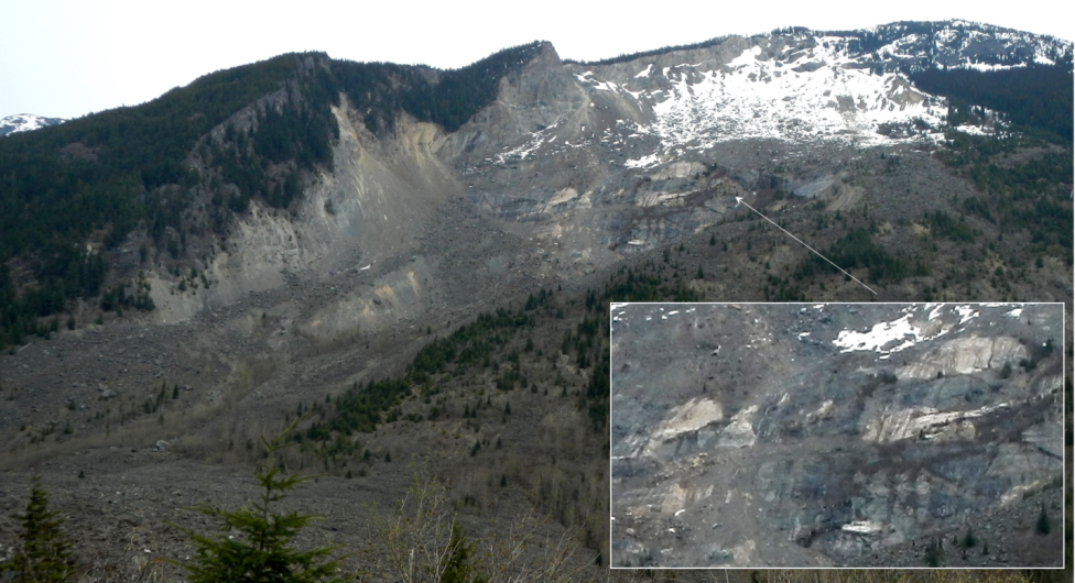
Figure \(\PageIndex{1}\): The site of the 1965 Hope Slide as seen in 2014. The initial failure is thought to have taken place along the foliation planes and sill within the area shown in the inset. © Steven Earle. CC BY
What can we learn from the Hope Slide? In general, we cannot prevent most mass wasting, and significant effort is required if an event is to be predicted with any level of certainty. Understanding the geology is critical to understanding mass wasting. Although failures are inevitable in a region with steep slopes, larger ones happen less frequently than smaller ones, and the consequences vary depending on the downslope conditions, such as the presence of people, buildings, roads, or fish-bearing streams.
An important reason for learning about mass wasting is to understand the nature of the materials that fail, and how and why they fail so that we can minimize risks from similar events in the future. For this reason, we need to be able to classify mass-wasting events, and we need to know the terms that geologists, engineers, and others use to communicate about them.
Mass wasting, which is synonymous with “slope failure,” is the failure and downslope movement of rock or unconsolidated materials in response to gravity. The term “landslide” is almost synonymous with mass wasting, but not quite because some people reserve “landslide” for relatively rapid slope failures, while others do not.
Classification of Mass Wasting Events
It’s important to classify slope failures so that we can understand what causes them and learn how to mitigate their effects. The three criteria used to describe slope failures are:
- The type of material that failed (typically either bedrock or unconsolidated sediment)
- The mechanism of the failure (how the material moved)
- The rate at which it moved
The type of motion is the most important characteristic of a slope failure, and there are three different types of motion:
- If the material drops through the air, vertically or nearly vertically, it’s known as a fall.
- If the material moves as a mass along a sloping surface (without internal motion within the mass), it’s a slide.
- If the material has internal motion, like a fluid, it’s a flow.
Unfortunately it’s not normally that simple. Many slope failures involve two of these types of motion, some involve all three, and in many cases, it’s not easy to tell how the material moved. The types of slope failure that we’ll cover here are summarized in Table \(\PageIndex{1}\).
| [Skip Table] | |||
| Failure Type | Type of Material | Type of Motion | Rate of Motion |
|---|---|---|---|
| Rock fall | Rock fragments | Vertical or near-vertical fall (plus bouncing in many cases) | Very fast (Greater than 10s of meters per second) |
| Rock slide | A large rock body | Motion as a unit along a planar surface (translational sliding) | Typically very slow (millimeters per year to centimeters per year), but some can be faster |
| Rock avalanche | A large rock body that slides and then breaks into small fragments | Flow (at high speeds the mass of rock fragments is suspended on a cushion of air) | Very fast (Greater than tens of meters per second) |
| Creep or solifluction | Soil or other overburden; in some cases, mixed with ice | Flow (although sliding motion may also occur) | Very slow (millimeters per year to centimeters per year) |
| Slump | Thick deposits (a metre to 10s of meters) of unconsolidated sediment | Motion as a unit along a curved surface (rotational sliding) | Slow (centimeters per year to meters per year) |
| Mudflow | Loose sediment with a significant component of silt and clay | Flow (a mixture of sediment and water moves down a channel) | Moderate to fast (centimeters per second to meters per second) |
| Debris flow | Sand, gravel, and larger fragments | Flow (similar to a mudflow, but typically faster) | Fast (meters per second) |
Rock Fall

Rock fragments can break off relatively easily from steep bedrock slopes, most commonly due to frost-wedging in areas where there are many freeze-thaw cycles per year. If you’ve ever hiked along a steep mountain trail on a cool morning, you might have heard the occasional fall of rock fragments onto a talus slope. This happens because the water between cracks freezes and expands overnight, and then when that same water thaws in the morning sun, the fragments that had been pushed beyond their limit by the ice fall to the slope below (Figure \(\PageIndex{2}\)).
A typical talus slope, near Keremeos in southern B.C., is shown in Figure \(\PageIndex{3}\). In December 2014, a large block of rock split away from a cliff in this same area. It broke into smaller pieces that tumbled down the slope and crashed into the road, smashing the concrete barriers and gouging out large parts of the pavement. Luckily no one was hurt.

Rock Slide
A rock slide is the sliding motion of rock along a sloping surface. In most cases, the movement is parallel to a fracture, bedding, or metamorphic foliation plane, and it can range from very slow to moderately fast. The word sackung describes the very slow motion of a block of rock (millimeters per year to centimeters per year) on a slope. A good example is the Downie Slide north of Revelstoke, B.C., which is shown in Figure \(\PageIndex{4}\). In this case, a massive body of rock is very slowly sliding down a steep slope along a plane of weakness that is approximately parallel to the slope. The Downie Slide, which was first recognized in the 1950s, prior to the construction of the Revelstoke Dam in the late 1970s, was moving very slowly at the time (a few centimeters per year). Geological engineers were concerned that the presence of water in the reservoir (visible in Figure \(\PageIndex{4}\)) could further weaken the plane of failure, leading to an acceleration of the motion. The result would have been a catastrophic failure into the reservoir that would have sent a wall of water over the dam and into the community of Revelstoke. During the construction of the dam they tunneled into the rock at the base of the slide and drilled hundreds of drainage holes upward into the plane of failure. This allowed water to drain out so that the pressure was reduced, which reduced the rate of movement of the sliding block. BC Hydro monitors this site continuously; the slide block is currently moving more slowly than it was prior to the construction of the dam.


In the summer of 2008, a large block of rock slid rapidly from a steep slope above Highway 99 near Porteau Cove (between Horseshoe Bay and Squamish). The block slammed into the highway and adjacent railway and broke into many pieces. The highway was closed for several days, and the slope was subsequently stabilized with rock bolts and drainage holes. As shown in Figure \(\PageIndex{5}\), the rock is fractured parallel to the slope, and this almost certainly contributed to the failure. However, it is not actually known what triggered this event as the weather was dry and warm during the preceding weeks, and there was no significant earthquake in the region.
Rock Avalanche

If a rock slides and then starts moving quickly (meters per second), the rock is likely to break into many small pieces, and at that point it turns into a rock avalanche, in which the large and small fragments of rock move in a fluid manner supported by a cushion of air within and beneath the moving mass. The 1965 Hope Slide (Figure \(\PageIndex{1}\)) was a rock avalanche, as was the famous 1903 Frank Slide in southwestern Alberta. The 2010 slide at Mount Meager (west of Lillooet) was also a rock avalanche, and rivals the Hope Slide as the largest slope failure in Canada during historical times (Figure \(\PageIndex{6}\)).
Creep or Solifluction

The very slow—millimeters per year to centimeters per year—movement of soil or other unconsolidated material on a slope is known as creep. Creep, which normally only affects the upper several centimeters of loose material, is typically a type of very slow flow, but in some cases, sliding may take place. Creep can be facilitated by freezing and thawing because, as shown in Figure \(\PageIndex{7}\), particles are lifted perpendicular to the surface by the growth of ice crystals within the soil, and then let down vertically by gravity when the ice melts. The same effect can be produced by frequent wetting and drying of the soil. In cold environments, solifluction is a more intense form of freeze-thaw-triggered creep.
Creep is most noticeable on moderate-to-steep slopes where trees, fence posts, or grave markers are consistently leaning in a downhill direction. In the case of trees, they try to correct their lean by growing upright, and this leads to a curved lower trunk known as a “pistol butt.” An example is shown on Figure \(\PageIndex{8}\).

Slump

Slump is a type of slide (movement as a mass) that takes place within thick unconsolidated deposits (typically thicker than 10 meters). Slumps involve movement along one or more curved failure surfaces, with downward motion near the top and outward motion toward the bottom (Figure \(\PageIndex{9}\)). They are typically caused by an excess of water within these materials on a steep slope.

An example of a slump in the Lethbridge area of Alberta is shown in Figure \(\PageIndex{10}\). This feature has likely been active for many decades, and moves a little more whenever there are heavy spring rains and significant snowmelt runoff. The toe of the slump is failing because it has been eroded by the small stream at the bottom.
Mudflows and Debris Flows

When a mass of sediment becomes completely saturated with water, the mass loses strength, to the extent that the grains are pushed apart, and it will flow, even on a gentle slope. This can happen during rapid spring snowmelt or heavy rains, and is also relatively common during volcanic eruptions because of the rapid melting of snow and ice. (A mudflow or debris flow on a volcano or during a volcanic eruption is a lahar.) If the material involved is primarily sand-sized or smaller, it is known as a mudflow, such as the one shown in Figure \(\PageIndex{11}\).
If the material involved is gravel sized or larger, it is known as a debris flow. Because it takes more gravitational energy to move larger particles, a debris flow typically forms in an area with steeper slopes and more water than does a mudflow. In many cases, a debris flow takes place within a steep stream channel, and is triggered by the collapse of bank material into the stream. This creates a temporary dam, and then a major flow of water and debris when the dam breaks. This is the situation that led to the fatal debris flow at Johnsons Landing, B.C., in 2012. A typical west-coast debris flow is shown in Figure \(\PageIndex{12}\). This event took place in November 2006 in response to very heavy rainfall. There was enough energy to move large boulders and to knock over large trees.

Factors that Control Slope Stability
Mass wasting happens because tectonic processes have created uplift. Erosion, driven by gravity, is the inevitable response to that uplift, and various types of erosion, including mass wasting, have created slopes in the uplifted regions. Slope stability is ultimately determined by two factors: the angle of the slope and the strength of the materials on it.

Figure \(\PageIndex{13}\) shows a block of rock situated on a rock slope. The block is being pulled toward Earth’s centre (vertically down) by gravity. We can split the vertical gravitational force into two components relative to the slope: one pushing the block down the slope (the shear force), and the other pushing into the slope (the normal force). The shear force, which wants to push the block down the slope, has to overcome the strength of the connection between the block and the slope, which may be quite weak if the block has split away from the main body of rock, or may be very strong if the block is still a part of the rock. This is the shear strength, and in Figure \(\PageIndex{13}\)a, it is greater than the shear force, so the block should not move. In Figure \(\PageIndex{13}\)b the slope is steeper and the shear force is approximately equal to the shear strength. The block may or may not move under these circumstances. In Figure \(\PageIndex{13}\)c, the slope is steeper still, so the shear force is considerably greater than the shear strength, and the block will very likely move.
As already noted, slopes are created by uplift followed by erosion. In areas with relatively recent uplift (such as most of British Columbia and the western part of Alberta), slopes tend to be quite steep. This is especially true where glaciation has taken place because glaciers in mountainous terrain create steep-sided valleys. In areas without recent uplift (such as central Canada), slopes are less steep because hundreds of millions of years of erosion (including mass wasting) has made them that way. However, as we’ll see, some mass wasting can happen even on relatively gentle slopes.
The strength of the materials on slopes can vary widely. Solid rocks tend to be strong, but there is a very wide range of rock strength. If we consider just the strength of the rocks, and ignore issues like fracturing and layering, then most crystalline rocks—like granite, basalt, or gneiss—are very strong, while some metamorphic rocks—like schist—are moderately strong. Sedimentary rocks have variable strength. Dolostone and some limestone are strong, most sandstone and conglomerate are moderately strong, and some sandstone and all mudstones are quite weak.
Fractures, metamorphic foliation, or bedding can significantly reduce the strength of a body of rock, and in the context of mass wasting, this is most critical if the planes of weakness are parallel to the slope and least critical if they are perpendicular to the slope. This is illustrated in Figure \(\PageIndex{14}\). At locations A and B the bedding is nearly perpendicular to the slope and the situation is relatively stable. At location D the bedding is nearly parallel to the slope and the situation is quite unstable. At location C the bedding is nearly horizontal and the stability is intermediate between the other two extremes.

Internal variations in the composition and structure of rocks can significantly affect their strength. Schist, for example, may have layers that are rich in sheet silicates (mica or chlorite) and these will tend to be weaker than other layers. Some minerals tend to be more susceptible to weathering than others, and the weathered products are commonly quite weak (e.g., the clay formed from feldspar). The side of Johnson Peak that failed in 1965 (Hope Slide) is made up of chlorite schist (metamorphosed sea-floor basalt) that has feldspar-bearing sills within it (they are evident within the inset area of Figure \(\PageIndex{1}\)). The foliation and the sills are parallel to the steep slope. The schist is relatively weak to begin with, and the feldspar in the sills, which has been altered to clay, makes it even weaker.
Unconsolidated sediments are generally weaker than sedimentary rocks because they are not cemented and, in most cases, have not been significantly compressed by overlying materials. This binding property of sediment is sometimes referred to as cohesion. Sand and silt tend to be particularly weak, clay is generally a little stronger, and sand mixed with clay can be stronger still. The deposits that make up the cliffs at Point Grey in Vancouver include sand, silt, and clay overlain by sand. As shown in Figure \(\PageIndex{15}\) (left) the finer deposits are relatively strong (they maintain a steep slope), while the overlying sand is relatively weak, and has a shallower slope that has recently failed. Glacial till—typically a mixture of clay, silt, sand, gravel, and larger clasts—forms and is compressed beneath tens to thousands of meters of glacial ice so it can be as strong as some sedimentary rock (Figure \(\PageIndex{15}\), right).
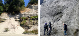 Figure \(\PageIndex{15}\) Left: Glacial outwash deposits at Point Grey, in Vancouver. The dark lower layer is made up of sand, silt, and clay. The light upper layer is well-sorted sand. Right: Glacial till on Quadra Island, B.C. The till is strong enough to have formed a near-vertical slope. © Steven Earle. CC BY
Apart from the type of material on a slope, the amount of water that the material contains is the most important factor controlling its strength. This is especially true for unconsolidated materials, like those shown in Figure \(\PageIndex{15}\), but it also applies to bodies of rock. Granular sediments, like the sand at Point Grey, have lots of spaces between the grains. Those spaces may be completely dry (filled only with air); or moist (often meaning that some spaces are water filled, some grains have a film of water around them, and small amounts of water are present where grains are touching each other); or completely saturated (Figure \(\PageIndex{16}\)). Unconsolidated sediments tend to be strongest when they are moist because the small amounts of water at the grain boundaries hold the grains together with surface tension. Dry sediments are held together only by the friction between grains, and if they are well sorted or well rounded, or both, that cohesion is weak. Saturated sediments tend to be the weakest of all because the large amount of water actually pushes the grains apart, reducing the mount friction between grains. This is especially true if the water is under pressure.

Water will also reduce the strength of solid rock, especially if it has fractures, bedding planes, or clay-bearing zones. This effect is even more significant when the water is under pressure, which is why you’ll often see holes drilled into rocks on road cuts to relieve this pressure. One of the hypotheses advanced to explain the 1965 Hope Slide is that the very cold conditions that winter caused small springs in the lower part of the slope to freeze over, preventing water from flowing out. It is possible that water pressure gradually built up within the slope, weakening the rock mass to the extent that the shear strength was no longer greater than the shear force.
Water also has a particular effect on clay-bearing materials. All clay minerals will absorb a little bit of water, and this reduces their strength. The smectite clays (such as the bentonite used in cat litter) can absorb a lot of water, and that water pushes the sheets apart at a molecular level and makes the mineral swell. Smectite that has expanded in this way has almost no strength; it is extremely slippery.
And finally, water can significantly increase the mass of the material on a slope, which increases the gravitational force pushing it down. A body of sediment that has 25% porosity and is saturated with water weighs approximately 13% more than it does when it is completely dry, so the gravitational shear force is also 13% higher. In the situation shown in Figure 15.2b, a 13% increase in the shear force could easily be enough to tip the balance between shear force and shear strength.
Mass-Wasting Triggers
In the previous section, we talked about the shear force and the shear strength of materials on slopes, and about factors that can reduce the shear strength. Shear force is primarily related to slope angle, and this does not change quickly. But shear strength can change quickly for a variety of reasons, and events that lead to a rapid reduction in shear strength are considered to be triggers for mass wasting.
An increase in water content is the most common mass-wasting trigger. This can result from rapid melting of snow or ice, heavy rain, or some type of event that changes the pattern of water flow on the surface. Rapid melting can be caused by a dramatic increase in temperature (e.g., in spring or early summer) or by a volcanic eruption. Heavy rains are typically related to major storms. Changes in water flow patterns can be caused by earthquakes, previous slope failures that dam up streams, or human structures that interfere with runoff (e.g., buildings, roads, or parking lots). An example of this is the deadly January 2005 debris flow in North Vancouver in the Riverside Drive area. The debris flow happened during a rainy period, but was likely triggered by excess runoff related to the roads at the top of this slope and by landscape features, including a pool. The 2005 failure took place in an area that had failed previously, and a report written in 1980 recommended that the municipal authorities and residents take steps to address surface and slope drainage issues. Little was done to improve the situation.
In some cases, a decrease in water content can lead to failure. This is most common with clean sand deposits (e.g., the upper layer in Figure \(\PageIndex{15}\) (left)), which lose strength when there is no water to hold the grains together.
Freezing and thawing can also trigger some forms of mass wasting. More specifically, the thawing can release a block of rock that was attached to a slope by a film of ice.
One other process that can weaken a body of rock or sediment is shaking. The most obvious source of shaking is an earthquake, but shaking from highway traffic, construction, or mining will also do the job. Several deadly mass-wasting events (including snow avalanches) were triggered by the M7.8 earthquake in Nepal in April 2015.
Saturation with water and then seismic shaking led to the occurrence of thousands of slope failures in the Sapporo area of Hokkaido, Japan in September 2018, as shown on Figure \(\PageIndex{18}\). The area was drenched with rain from tropical storm Jebi on September 4th. On September 6th it was shaken by a M6.6 earthquake which triggered debris flows in the water-saturated volcanic materials on steep slopes. There were 41 deaths related to the slope failures.
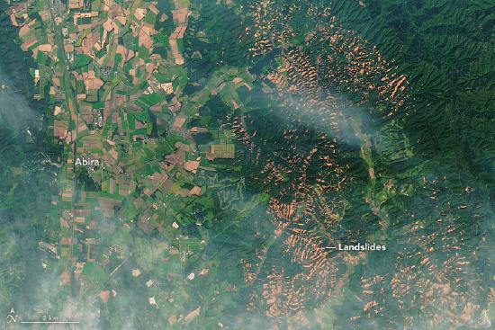 Figure \(\PageIndex{18}\) Slope failures in the Sapporo area of Japan following a typhoon (Sept. 4th, 2018) and earthquake (Sept. 6th, 2018) (Before and after Landsat 8 images: top: July 2017, bottom: September 2018). Source: “Landslides in Hokkaido” by Lauren Dauphin, NASA Earth Observatory. Public domain.
Contributors and Attributions
Modified by Kyle Whittinghill from the following sources
- Mass Wasting, Factors that Control Slope Stability, and Classification of Mass Wasting from Physical Geology by Steven Earle (licensed under a Creative Commons Attribution 4.0 International License)