
13.5: Designing Protected Areas
- Page ID
- 49861

The unplanned way in which protected areas have historically been established means that their design may at times impede rather than aid their goals. For example, many protected areas are too small to sustain viable populations of the species they are meant to protect. To avoid and mitigate such mistakes, conservation biologists are increasingly exploring methods to design more efficient protected areas networks.
Conservation biologists often start the process of designing protected areas networks by considering “the four Rs”:
- Representation: A network of protected areas should protect as much of the biodiversity (including species, ecosystems, genetic diversity, ecosystem processes, etc.) of a region, country, or subcontinent (depending on the scale of planning) as possible.
- Resiliency: Protected areas should be large enough that they can maintain biodiversity (including species, ecosystems, genetic diversity, etc.) for the foreseeable future, including in the face of climate change and natural disasters such as cyclones/hurricanes and uncontrollable wildfires.
- Redundancy: A network of protected areas should not rely on a single protected area to conserve key aspects of a region’s biodiversity; rather important aspects of biodiversity should be included in multiple protected areas to ensure their long-term existence.
- Reality: Each protected area requires sufficient funding, political will, defensibility, and local buy-in to support biodiversity over the long term.
In addition to the four Rs (which can also be applied to species protection), the following questions can also help guide planning of protected area networks (Figure 13.5):
- How large of an area must be protected and what landscape features must it include to effectively and sustainably protect biodiversity that may not be able to persist outside it?
- Is a single large protected area better, or are multiple smaller reserves more effective?
- What shape should a protected area be?
- When creating multiple protected areas, should conservation managers create them near one another or far apart? Should they be connected in some way, or should they be isolated from one another?
- How should human activities be accommodated? What activities should be allowed?

To prepare readers for discussions with land managers, conservation planners, and policy makers who are in the process of developing new protected areas, the next section introduces some of the most important principles related to protected areas design. It is important to note that this introduction is not meant to serve as a universal set of rules for the design of protected areas. Because every project presents a special and unique set of circumstances, a single set of simplistic or overly general guidelines will not suffice. Also, the principles discussed below have been explored mainly in terms of protecting terrestrial vertebrates, vascular plants, and large invertebrates, so it is still uncertain how they apply to freshwater and marine nature protected areas.
What size should a protected area be?
The design of protected areas, and their size, is often addressed through the lens of the island biogeography model that states that large islands can accommodate more species and larger populations than small islands (Section 5.1). Research on extinction rates of populations (Newmark, 1996; Woodroffe and Ginsberg, 1998) and species richness (Harcourt et al., 2001; Brashares et al., 2001) has shown that protected areas function very much like islands. Specifically, because large protected areas contain greater habitat diversity than small protected areas, larger protected areas can accommodate (a) more species, (b) a larger range of ecosystem processes, and (c) viable populations of large species that range over large areas and live at low densities.
Large protected areas are generally preferred over small ones because they can support a greater variety of ecosystems and larger wildlife populations.
Given the range of costs and benefits of establishing large protected areas, conservation biologists have debated whether creating a single large reserve or several small reserves of the same total area—known as the SLOSS (Single Large Or Several Small) debate—is better. As discussed in Section 5.1.1, habitat fragmentation is currently one of the main drivers of species extinctions; it divides large populations into more vulnerable subpopulations, leads to undesirable edge effects, creates barriers to dispersal, and provides entry points for invasive species. These negative impacts are also of concern for protected areas, especially those that are small and fragmented (leading to larger perimeter:area ratios). For example, fragmentation concentrates elephants (Vanak et al., 2010) and apex predators (Cozzi et al., 2013) in the core of protected areas, greatly limiting the effective protected area for these taxa. However, these same impacts do not alter ungulate foraging (Kiffner et al., 2013), leading, potentially, to overgrazing near reserve borders. Studies have also shown how wildlife experience higher levels of mortality near protected area boundaries (Balme et al., 2010). Ignoring such edge effects could disrupt the long-term conservation value of a protected area, particularly small ones that could effectively function as edge habitat in its entirety. Because one big fragmented reserve has many of the characteristics of several small protected areas, conservation planners should aim to establish properly-placed large protected areas and to keep them as intact as possible. It is thus good practice to restrict and even remove highways, fences, farms, logging operations, and other human activities inside protected areas because of how they fragment habitats and reduce habitat availability overall.
But how do we know when a protected area is big enough? Ultimately, optimal size depends on the area over which important natural processes take place, which varies depending on the ecosystem. In some cases, the functional size may be quite small, such as a desert spring, a mountain bog, or a rocky outcrop. In contrast, the functional size of tropical forests, seasonal drylands, and desert communities are typically quite large, possibly spanning across country borders. Understanding and planning for protecting these different targets thus requires a familiarity with the functioning and ecology of each ecosystem.
When considering the size of a proposed protected area, conservation managers must also consider how well the area can be monitored and defended from threats. In some instances, an entire community may be incorporated into a relatively small protected area that is easy to monitor and defend against pollution, invasive species, and so forth. More often however, only a portion of the target community can be protected. In such cases it is important to consider how secure the conservation target will ultimately be. For example, if an aquatic organism needs protection, clearly the protection of its immediate habitat is critical. However, if a major threat is upstream from its habitat, then protection of the immediate habitat alone will be insufficient. Instead, managers would need to find ways to prevent outside threats from impacting populations inside the protected area. One option could be to discuss the threats and how to mitigate them with surrounding landowners, perhaps by facilitating their adoption of sustainable land-use practices. If the magnitude of the threats cannot be reduced to acceptable levels, a prioritization program might be used to identify critical sub-components of a larger ecosystem that will still accomplish the necessary protection. These kinds of considerations can become very complex and involved. But they are also very important to consider as options, especially when dealing with ecosystems situated between a variety of stakeholders.
Zoning as a solution to conflicting demands
While the general consensus seems to be that larger protected areas are better than smaller ones, establishing a properly-placed large protected area can be an imposing challenge. In a few special cases, large protected areas may be established through cooperation between multiple levels of society. More often, however, conservation biologists are faced with limited resources, and stakeholders can reasonably ask why a large park is required in an area that can otherwise be used to support agriculture or other types of businesses that may provide quick profits and jobs.
One way to deal with such conflicting demands while still achieving the target of protecting a large area is through a method called mixed-use zoning. Mixed-use zoning prioritises the overall conservation objectives for a protected area but also sets aside designated areas where certain regulated human activities are permitted (Box 13.4). In this way, some areas (or zones) may be designated for subsistence agriculture, shade-grown crops, timber production, hunting, ecotourism, or water management. Other areas are designated are dedicated to recovery of threatened species, ecotourism, ecosystem restoration, and scientific research. This is the case at the W-Arly-Pendjari (WAP) Complex, which straddles the border zone between Benin, Burkina Faso, and Niger. The core of the complex consists of three national parks covering 14,948 km2, set aside for strict biodiversity conservation. These national parks are surrounded by as many as 16 additional reserves, partial reserves, and hunting concessions, bringing the total area of protected Sudano-Sahelian savannah to 26,000 km2 (WHC, 2018).
Mixed-use zones sets aside areas for certain regulated human activities within a larger conservation area. This approach helps abate conflicting land use pressure.
Richard Carroll1,2
1World Wildlife Fund,
Washington DC, USA.
2Current address:
The Pimm Group, Nicholas School of the Environment,
Duke University, Durham, NC, USA.
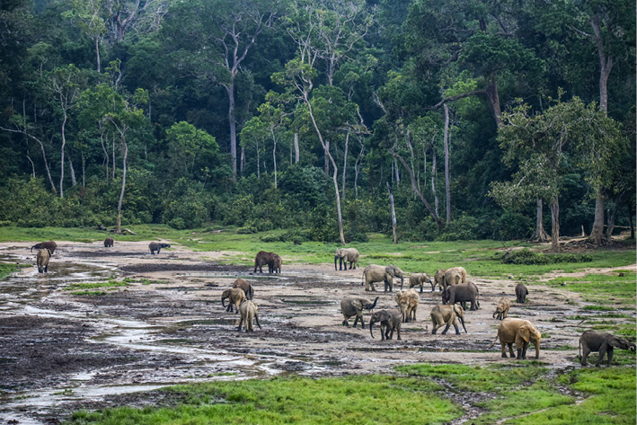
Located in the dense forests of southwestern Central African Republic (CAR), in a wedge between neighbouring Cameroon to the West and the Republic of the Congo to the East, the Dzanga-Sangha Project (DSP) aims to conserve CAR’s last lowland tropical forest by integrating conservation and regional development. The DSP, which formally began in 1988 with the establishment of a cooperative agreement between WWF and the CAR government, is an integrated conservation and development project (ICDP); its activities are focused on protected area management, rural development, tourism, and project administration, as well as sustainable use of natural resources and applied ecological and social research. The focal area of the DSP is the Dzanga-Sangha Complex of Protected Areas (Figure 13.E), an area of 4,589 km2 comprising the Dzanga-Sangha Special Reserve (3,359 km2) and Dzanga Ndoki National Park (1,143 km2). The Complex is home to healthy populations of forest elephant (Figure 13.F), western lowland gorilla (Gorilla gorilla gorilla, CR), chimpanzee, and other wildlife characteristic of the Northwest Congolian Moist Lowland Forest (Carroll, 1992). The forest also shelters the BaAka Pygmies, a hunter-gatherer community whose traditional livelihood is directly linked to the forest and its plant and wildlife resources (Robinson and Remis, 2014).

Many of the WWF-supported programs in Central Africa have sought to create the conditions for traditional peoples, such as Pygmies to maintain their lifestyles, and to adapt to changing social conditions should they choose. In the case of the DSP, two-thirds of the Complex area is classified as a “Special Reserve”, a designation that the CAR government created to accommodate traditional peoples’ use of the forest. While traditional hunting and gathering are broadly allowed in the Special Reserve, national laws specifically prohibit hunting of “integrally protected species”, such as gorillas, chimpanzees and elephants, in the Complex and elsewhere in CAR.
To establish a “safe zone” where wildlife can reproduce away from human pressures (Blom et al., 2004), and to accommodate tourism, one third of the Complex is designated as a national park. Hunting is not allowed in the national park; as compensation, 40% of all tourist receipts go to a village association, which includes BaAka, and 50% pays salaries for local employees of the park and special reserve. In other words, 90% of the dividends earned from tourism activities goes to the local people affected by conservation activities. The local community by and large supports the designation of this no-hunting zone, both to sustain their traditional activities and those of tourists.
Building on the successes in CAR, the DSP is also an active partner in the 36,000 km2 transboundary Sangha Tri-National (STN) initiative. Reflecting the Peace Park concept, the initiative is a multi-national effort to protect a large block of contiguous forests, the heart of which lies at the meeting point of the Congo-CAR-Cameroon boundaries. This initiative includes CAR’s Dzanga-N’Doki National Park, as well as two adjacent national parks: Cameroon’s Lobéké National Park (430 km2) and Republic of the Congo’s Nouabalé-Ndoki National Park (4,190 km2). These three national parks are surrounded by extensive buffer zones that include the Dzanga-Sangha Special Reserve, forests around Lobeke (700 km2) and the peripheral zone in Republic of the Congo with almost 12,000 km2 of logging concessions. STN was declared as the first landscape level World Heritage Site in 2012.
In summary, the Dzanga-Sangha Project is an ambitious, long-term effort of the CAR government, WWF, and other participating partners to save the largest and most biologically diverse tract of forest remaining in the region. Moreover, the evolution of the STN initiative demonstrates the shift from site-focused conservation to a more eco-regional or landscape strategy that incorporates the impact of human activities and the movement of animal populations across international boundaries.
Through its Biosphere Reserves program, UNESCO has pioneered a formal zoning approach that integrates human activities, scientific research, biodiversity conservation, and tourism at a single location (Coetzer et al., 2014). A biosphere reserve is divided into three zones to delineate different levels of human use (Figure 13.6). The core of a typical biosphere reserve is a no-take zone (also called a core zone), strictly protected for biodiversity and ecosystem functioning. Around the core area is a restricted-use buffer zone, where people can conduct traditional, low-impact activities, such as collecting edible plants and small amounts of wood for fuel, and scientists can conduct non-destructive research. Outside of the buffer zone is a transition zone that allows some sustainable development (such as small-scale farming) and some medium-impact natural resource extraction (such as selective logging and fishing). As of mid-2019, there were 73 UNESCO Biosphere Reserves in 26 different Sub-Saharan African nations (http://www.unesco.org/new/en/natural-sciences); new reserves are regularly being added.

Zoning is also proving effective in resolving conflicting demands over marine environments. Like terrestrial biosphere reserves, zoned MPAs consist of core zones where marine organisms can escape and recover from human disturbances, and multiple-use zones where activities such as harvesting of natural resources are permitted. Of course, harvesting fish and other marine species is not the only human activity that needs to be regulated. For example, many marine organisms are sensitive to anthropogenic noise, which interferes with communication and other important behaviors (Shannon et al., 2015). Creating multiple types of multiple-use areas can allow for different intensities of human activities. The is well illustrated at Eritrea’s Sheik Said Marine National Park; here, only approved scientific research is allowed in the restricted zone, low-impact ecotourism activities such as snorkelling and spiritual activities are allowed in the sanctuary zone, while noisy motorboats and limited take are allowed in the habitat protection zone (Habtemariam and Fang, 2016).
Zoned marine protected areas include core zones where marine organisms can escape human disturbance, and multiple-use zones where certain activities are permitted.
While resolving conflicting demands for space, zoning also provides benefits to biodiversity and people. For example, when compared to nearby unprotected sites, zoned MPAs typically have greater total weight of commercially important fish, greater numbers of individual fish, and greater coral reef cover (Lester et al., 2009). Conditions that allow marine organisms within MPAs to thrive, in turn, create opportunities for fish and other sea creatures to spill from the MPA into adjacent unprotected areas where they can be caught by local fishers, with a goal of a more sustainable harvest overall. A study from South Africa evaluated this hypothesis by attaching radio transmitters onto several white stumpnose (Rhabdosargus globiceps VU), an important fish for both commercial and recreational fisheries (Kerwath et al., 2009). This study showed that tagged fish spent 50% of their time outside the MPA, which would make them theoretically available to fishermen half of the time, while fish that did not leave protected waters produced offspring that could later disperse into multiple-use areas.
Despite the clear benefits of zoning, enforcing restrictions remains a major challenge. Even with good public outreach efforts and the threat of fines, harvesters of natural resources may still move toward and sometimes even into restricted zones to access more abundant or accessible natural resources. The resultant overharvesting at the margins of protected areas may prevent wildlife from dispersing into a wider area, which then make it hard for people that abide by the rules to access natural resources. The primary challenge in zoning is thus to find a compromise that the various stakeholders are willing to accept, and that provides opportunities for the long-term sustainable use of natural resources. Once those compromises have been agreed upon, a combination of local involvement, public outreach, clear posting of information signs, and visible enforcement of zoning restrictions can significantly increase the success of a zoning plan.
Connectivity among protected areas
Although large protected areas are preferable to smaller ones, sometimes small protected areas are the only available option, and conservation biologists must figure out how to protect biodiversity in these small areas. This is important in an African context, where most protected areas are very small, and only very few are sufficiently large to truly fulfil biodiversity needs (Table 13.3). To help conservation biologists meet this challenge, there is a growing body of evidence showing that small protected areas, even ones less than a hectare, can in fact be effective at maintaining viable wildlife populations. But how can that be? Does it suggest that small conservation areas are also useful for conservation purposes?
|
Name |
Location |
Size (km2) |
Established |
|---|---|---|---|
|
Prince Edward Island Marine Protected Area |
South Africa |
181,230 |
2013 |
|
Termit & Tin Toumma National Nature and Cultural Reserve |
Niger |
97,000 |
2012 |
|
Ouadi Rimé-Ouadi Achim Faunal Reserve |
Chad |
77,950 |
1969 |
|
Air and Ténéré Reserves |
Niger |
77,360 |
1988 |
|
Central Kalahari Game Reserve |
Botswana |
52,800 |
1961 |
|
Namib-Naukluft National Park |
Namibia |
49,768 |
1979 |
|
Borana Controlled Hunting Area |
Ethiopia |
45,366 |
1973 |
|
Selous Game Reserve |
Tanzania |
44,000 |
1905 |
|
Ngiri-Tumba-Maindombe* |
DRC |
65,696 |
2008 |
|
Okavango Delta system* |
Botswana |
55,374 |
1996 |
Source: https://www.protectedplanet.net
* Ramsar wetlands
One of the main reasons why some wildlife populations can persist in small protected areas is that these areas violate an important assumption—that protected areas are isolated from one another. But we now know that wildlife populations often disperse between protected areas through the surrounding habitat matrix (Pryke et al., 2015). This dispersal maintains both metapopulation dynamics (Section 11.3) and reduces the risk of deleterious genetic effects (Section 8.7.1), allowing a network of small protected areas to effectively function as one large conservation area (Wegmann et al., 2014). In contrast, reserve isolation create population sinks for wildlife meant to be protected (Newmark, 2008). Consequently, re-establishing or maintaining connectivity within protected areas networks, and particularly among small reserves, has become an important strategy for enhancing their conservation value
Landscape connectivity may enable a network of small protected areas to effectively function as one large conservation area.
Many of the strategies used to maintain and restore ecosystem connectivity (Section 11.3) can be applied to protected areas management. However, this can be challenging given that administrative boundaries seldom consider natural ecosystem boundaries (Dallimer and Strange, 2015). Consequently, many ecosystems are artificially divided between different countries, each with its own development needs and management styles. Furthermore, many border barriers meant to restrict movement of people also restrict wildlife movement.
Transfrontier conservation areas enable two or more countries to collaboratively manage a shared ecosystem for mutual benefit.
Bioregional management seeks to conserve such large ecosystems that cross political borders. One way to accomplish this is to establish a transfrontier conservation area (TFCA) (also known as Peace Park or transboundary protected area), in which two or more countries collaboratively manage a shared ecosystem for mutual benefit (Hanks, 2008; see also Box 2.2 and Box 11.3). In addition to pooling scarce resources, this cooperative management style often includes removal of human-made physical barriers such as fences to allow free movement of animals (and sometimes also people, such as pastoralists) within the TFCA (Section 11.3.1). Sub-Saharan Africa first transboundary protected area was created in 1954, with the establishment of W National Park in Benin, Burkina Baso, and Niger, so named because the River Niger is shaped like letter “W” in this area. But it was only after the creation of the Peace Parks Foundation in 1997, and the Kgalagadi Transfrontier Park 2000, on the border between Botswana and South Africa (Anderson et al., 2013), that the concept gained widespread popularity in the region.
What about small isolated reserves?
At times, there will be no other choice than to accept that a small reserve is the only option available to achieve in situ conservation. In those cases, it is certainly better to accept the challenge. For many species, especially plants, a small protected area is the only buffer they have against extinction (Wintle et al., 2019). Biologists in South Africa have also pioneered an initiative to maintain species that require large home ranges in small, isolated protected areas by artificially managing dispersal dynamics (see Box 8.3). Small reserves, especially those located in or near populated areas (see Box 14.2), can also serve as locations for public outreach, conservation education, recreation, and citizen science that can improve public engagement with nature and awareness of conservation issues (Miller and Hobbs, 2002). Lastly, in addition to serving as stepping stones (Section 11.3.1), even small protected areas in urban areas provide various ecosystem services, including mitigating the urban heat island effect and reducing flooding (Feyisa et al., 2014, see also Section 7.1.6). In each of these cases, conservation biologists must creatively consider how to replicate natural processes across a small and/or fragmented protected areas network to ensure that they function on a scale that will maintain the target populations and communities.