Biology LibreTexts

13.4: Soil Degradation

  • Page ID
    69491
  • \( \newcommand{\vecs}[1]{\overset { \scriptstyle \rightharpoonup} {\mathbf{#1}} } \)

    \( \newcommand{\vecd}[1]{\overset{-\!-\!\rightharpoonup}{\vphantom{a}\smash {#1}}} \)

    \( \newcommand{\id}{\mathrm{id}}\) \( \newcommand{\Span}{\mathrm{span}}\)

    ( \newcommand{\kernel}{\mathrm{null}\,}\) \( \newcommand{\range}{\mathrm{range}\,}\)

    \( \newcommand{\RealPart}{\mathrm{Re}}\) \( \newcommand{\ImaginaryPart}{\mathrm{Im}}\)

    \( \newcommand{\Argument}{\mathrm{Arg}}\) \( \newcommand{\norm}[1]{\| #1 \|}\)

    \( \newcommand{\inner}[2]{\langle #1, #2 \rangle}\)

    \( \newcommand{\Span}{\mathrm{span}}\)

    \( \newcommand{\id}{\mathrm{id}}\)

    \( \newcommand{\Span}{\mathrm{span}}\)

    \( \newcommand{\kernel}{\mathrm{null}\,}\)

    \( \newcommand{\range}{\mathrm{range}\,}\)

    \( \newcommand{\RealPart}{\mathrm{Re}}\)

    \( \newcommand{\ImaginaryPart}{\mathrm{Im}}\)

    \( \newcommand{\Argument}{\mathrm{Arg}}\)

    \( \newcommand{\norm}[1]{\| #1 \|}\)

    \( \newcommand{\inner}[2]{\langle #1, #2 \rangle}\)

    \( \newcommand{\Span}{\mathrm{span}}\) \( \newcommand{\AA}{\unicode[.8,0]{x212B}}\)

    \( \newcommand{\vectorA}[1]{\vec{#1}}      % arrow\)

    \( \newcommand{\vectorAt}[1]{\vec{\text{#1}}}      % arrow\)

    \( \newcommand{\vectorB}[1]{\overset { \scriptstyle \rightharpoonup} {\mathbf{#1}} } \)

    \( \newcommand{\vectorC}[1]{\textbf{#1}} \)

    \( \newcommand{\vectorD}[1]{\overrightarrow{#1}} \)

    \( \newcommand{\vectorDt}[1]{\overrightarrow{\text{#1}}} \)

    \( \newcommand{\vectE}[1]{\overset{-\!-\!\rightharpoonup}{\vphantom{a}\smash{\mathbf {#1}}}} \)

    \( \newcommand{\vecs}[1]{\overset { \scriptstyle \rightharpoonup} {\mathbf{#1}} } \)

    \( \newcommand{\vecd}[1]{\overset{-\!-\!\rightharpoonup}{\vphantom{a}\smash {#1}}} \)

    \(\newcommand{\avec}{\mathbf a}\) \(\newcommand{\bvec}{\mathbf b}\) \(\newcommand{\cvec}{\mathbf c}\) \(\newcommand{\dvec}{\mathbf d}\) \(\newcommand{\dtil}{\widetilde{\mathbf d}}\) \(\newcommand{\evec}{\mathbf e}\) \(\newcommand{\fvec}{\mathbf f}\) \(\newcommand{\nvec}{\mathbf n}\) \(\newcommand{\pvec}{\mathbf p}\) \(\newcommand{\qvec}{\mathbf q}\) \(\newcommand{\svec}{\mathbf s}\) \(\newcommand{\tvec}{\mathbf t}\) \(\newcommand{\uvec}{\mathbf u}\) \(\newcommand{\vvec}{\mathbf v}\) \(\newcommand{\wvec}{\mathbf w}\) \(\newcommand{\xvec}{\mathbf x}\) \(\newcommand{\yvec}{\mathbf y}\) \(\newcommand{\zvec}{\mathbf z}\) \(\newcommand{\rvec}{\mathbf r}\) \(\newcommand{\mvec}{\mathbf m}\) \(\newcommand{\zerovec}{\mathbf 0}\) \(\newcommand{\onevec}{\mathbf 1}\) \(\newcommand{\real}{\mathbb R}\) \(\newcommand{\twovec}[2]{\left[\begin{array}{r}#1 \\ #2 \end{array}\right]}\) \(\newcommand{\ctwovec}[2]{\left[\begin{array}{c}#1 \\ #2 \end{array}\right]}\) \(\newcommand{\threevec}[3]{\left[\begin{array}{r}#1 \\ #2 \\ #3 \end{array}\right]}\) \(\newcommand{\cthreevec}[3]{\left[\begin{array}{c}#1 \\ #2 \\ #3 \end{array}\right]}\) \(\newcommand{\fourvec}[4]{\left[\begin{array}{r}#1 \\ #2 \\ #3 \\ #4 \end{array}\right]}\) \(\newcommand{\cfourvec}[4]{\left[\begin{array}{c}#1 \\ #2 \\ #3 \\ #4 \end{array}\right]}\) \(\newcommand{\fivevec}[5]{\left[\begin{array}{r}#1 \\ #2 \\ #3 \\ #4 \\ #5 \\ \end{array}\right]}\) \(\newcommand{\cfivevec}[5]{\left[\begin{array}{c}#1 \\ #2 \\ #3 \\ #4 \\ #5 \\ \end{array}\right]}\) \(\newcommand{\mattwo}[4]{\left[\begin{array}{rr}#1 \amp #2 \\ #3 \amp #4 \\ \end{array}\right]}\) \(\newcommand{\laspan}[1]{\text{Span}\{#1\}}\) \(\newcommand{\bcal}{\cal B}\) \(\newcommand{\ccal}{\cal C}\) \(\newcommand{\scal}{\cal S}\) \(\newcommand{\wcal}{\cal W}\) \(\newcommand{\ecal}{\cal E}\) \(\newcommand{\coords}[2]{\left\{#1\right\}_{#2}}\) \(\newcommand{\gray}[1]{\color{gray}{#1}}\) \(\newcommand{\lgray}[1]{\color{lightgray}{#1}}\) \(\newcommand{\rank}{\operatorname{rank}}\) \(\newcommand{\row}{\text{Row}}\) \(\newcommand{\col}{\text{Col}}\) \(\renewcommand{\row}{\text{Row}}\) \(\newcommand{\nul}{\text{Nul}}\) \(\newcommand{\var}{\text{Var}}\) \(\newcommand{\corr}{\text{corr}}\) \(\newcommand{\len}[1]{\left|#1\right|}\) \(\newcommand{\bbar}{\overline{\bvec}}\) \(\newcommand{\bhat}{\widehat{\bvec}}\) \(\newcommand{\bperp}{\bvec^\perp}\) \(\newcommand{\xhat}{\widehat{\xvec}}\) \(\newcommand{\vhat}{\widehat{\vvec}}\) \(\newcommand{\uhat}{\widehat{\uvec}}\) \(\newcommand{\what}{\widehat{\wvec}}\) \(\newcommand{\Sighat}{\widehat{\Sigma}}\) \(\newcommand{\lt}{<}\) \(\newcommand{\gt}{>}\) \(\newcommand{\amp}{&}\) \(\definecolor{fillinmathshade}{gray}{0.9}\)

    Once fertile topsoil is lost, it is not easily replaced. Soil degradation refers to deterioration in the quality of the soil and the resultant reduction in its capacity to produce. Soils are degraded primarily by erosion, compaction, and salinization. Such processes often arise from poor soil management during agricultural activities. In extreme cases, soil degradation can lead to desertification (conversion of land to desert-like conditions) of croplands and rangelands in semi-arid regions. See the Sustainable Agriculture section for strategies to preserve soil quality (soil conservation).

    Erosion

    Erosion is the biggest cause of soil degradation. Soil productivity is reduced as a result of losses of nutrients, water holding capacity, and organic matter. Water holding capacity is a measure of of the soils ability to retain water. The two agents of erosion are wind and water, which act to remove the finer particles from the soil. Wind erosion occurs mostly in flat, dry areas and moist, sandy areas along bodies of water. Wind not only removes soil, but also dries and degrades the soil structure. Water erosion is the most prevalent type of erosion. It occurs when raindrops splash on the ground and when water moves down slope as a thin film, small streams, or a large stream.

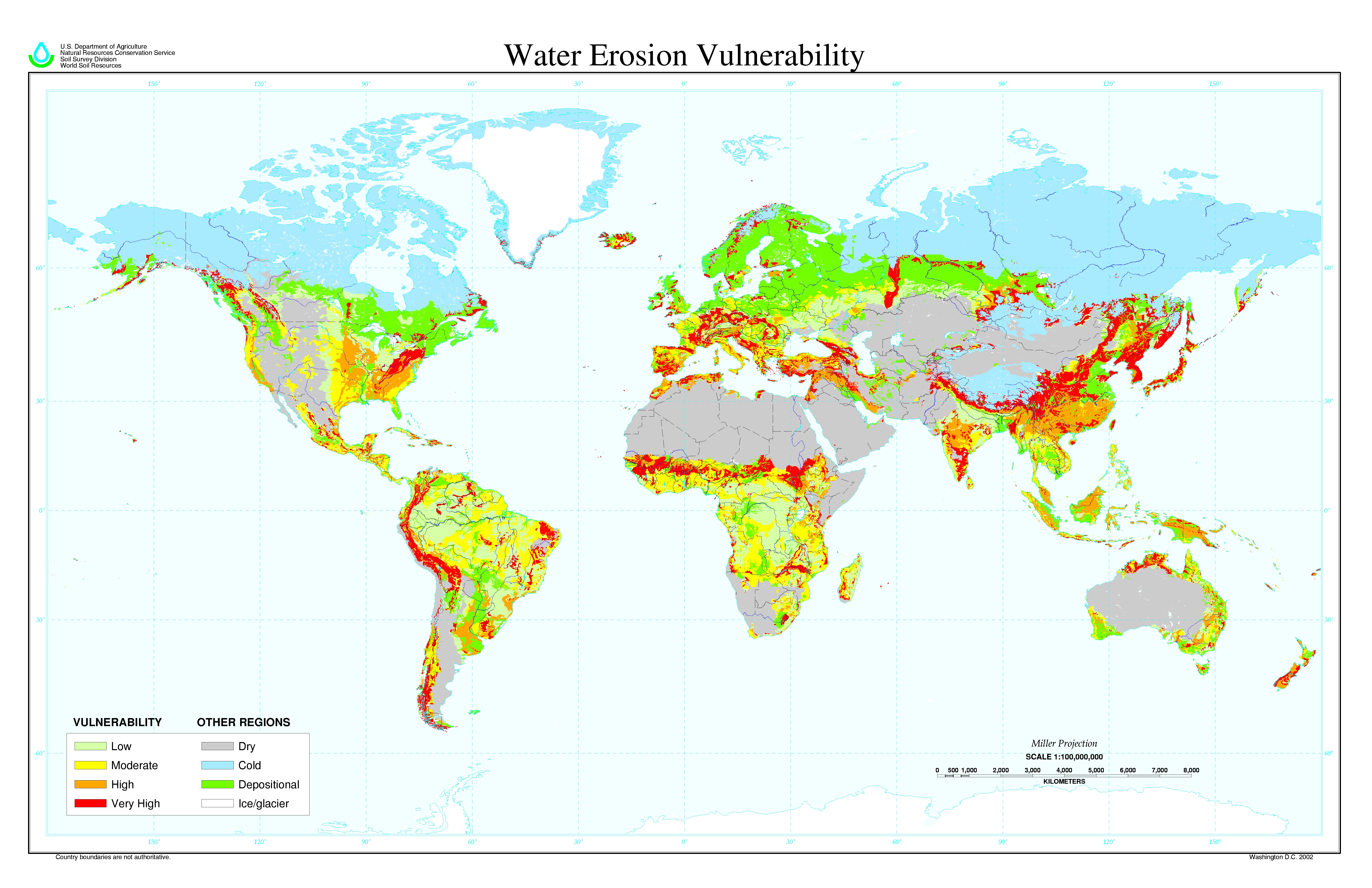
    Some amount of soil erosion is a natural process along sloping areas and/or in areas with soft or materials that do not stick together and are susceptible to movement by water, wind, or gravity. For instance, soil material can be mobilized in strong windstorms, along the banks of rivers, in landslides, or by wave action along coastlines. However, human activities such as construction, logging, and off-road vehicle use promote erosion by removing the natural vegetation cover protecting the soil. Agricultural practices such as overgrazing and leaving plowed fields bare for extended periods contribute to farmland erosion. Each year, an estimated two billion metric tons of soil are eroded from farmlands in the United States alone. The soil transported by the erosion processes can also create problems elsewhere (for example, by clogging waterways and filling ditches and low-lying land areas). The areas most vulnerable to soil erosion include locations with thin organic (A and O) horizons and hilly terrains (figure \(\PageIndex{a}\)).

    A world map identifying areas vulnerable to water erosion
    Figure \(\PageIndex{a}\): Global map of water erosion vulnerability. There are four levels of vulnerability: very high (red), high (orange), moderate (yellow), and low (light green). Examples of regions with very high vulnerability to erosion by water include the west coast of South America, parts of the eastern United States, regions around the Mediterranean Sea, a strip across western and central Africa, Korean and Japan, Northern Australia, and New Zealand. Examples of regions with low vulnerability include northern South America, the Democratic Republic of Congo, northern India and Nepal, and western Russia. Other regions are labeled as dry (gray), cold (light blue), depositional (bright green), or ice/glacier (white). For example, northern regions are cold and ice/glacier. Much of the western United States, Chile and Argentina, northern Africa, the Middle East, Kazakhstan, Mongolia, and much of Australia are considered dry. The largest depositional area (region where sediments accumulate) is northeastern Europe. Image by USDA-NRCS, Soil Science Division, World Soil Resources (public domain).

    Compaction

    In modern agricultural practices, heavy machinery is used to prepare the seedbed, for planting, to control weeds, and to harvest the crop. The use of heavy equipment has many advantages in saving time and labor, but can cause compaction of soil and disruption of the natural soil biota. Much compaction is reversible and some is unavoidable with modern practices; however, serious compaction issues can occur when the equipment is used excessively during times when the soil has a high water content. The problem with soil compaction is that increased soil density limits root penetration depth and may inhibit proper plant growth.

    Salinization

    When considerable quantities of salt accumulate in the soil in a process known as salinization, many plants are unable to grow properly or even survive. This is especially a problem in irrigated farmland. Groundwater used for irrigation contains small amounts of dissolved salts. Irrigation water that is not absorbed into the soil evaporates, leaving the salts behind. This process repeats itself and eventually severe salinization of the soil occurs. A related problem is water logging of the soil. When cropland is irrigated with excessive amounts of water in order to leach salts that have accumulated in the soil, the excess water is sometimes unable to drain away properly. In this case it accumulates underground and causes a rise in the subsurface water table. If the saline water rises to the level of the plant roots, plant growth is inhibited.

    Desertification

    Land that was previously suited for growing crops may be turned into desert by climate change and the activities of humans, such as poor farming practices, livestock overgrazing, and overuse of available water. This process, called desertification, is a serious problem worldwide. Plants and soil types that are non-arid (not dry) specifically help water soak into the ground (infiltration) and water retention. When desertification begins, it leads to a reduction in vegetation and degraded soil quality, and this further increases the aridity and spreads the desert via a positive feedback loop (meaning that the processes feed on themselves promoting an increasing spiral).

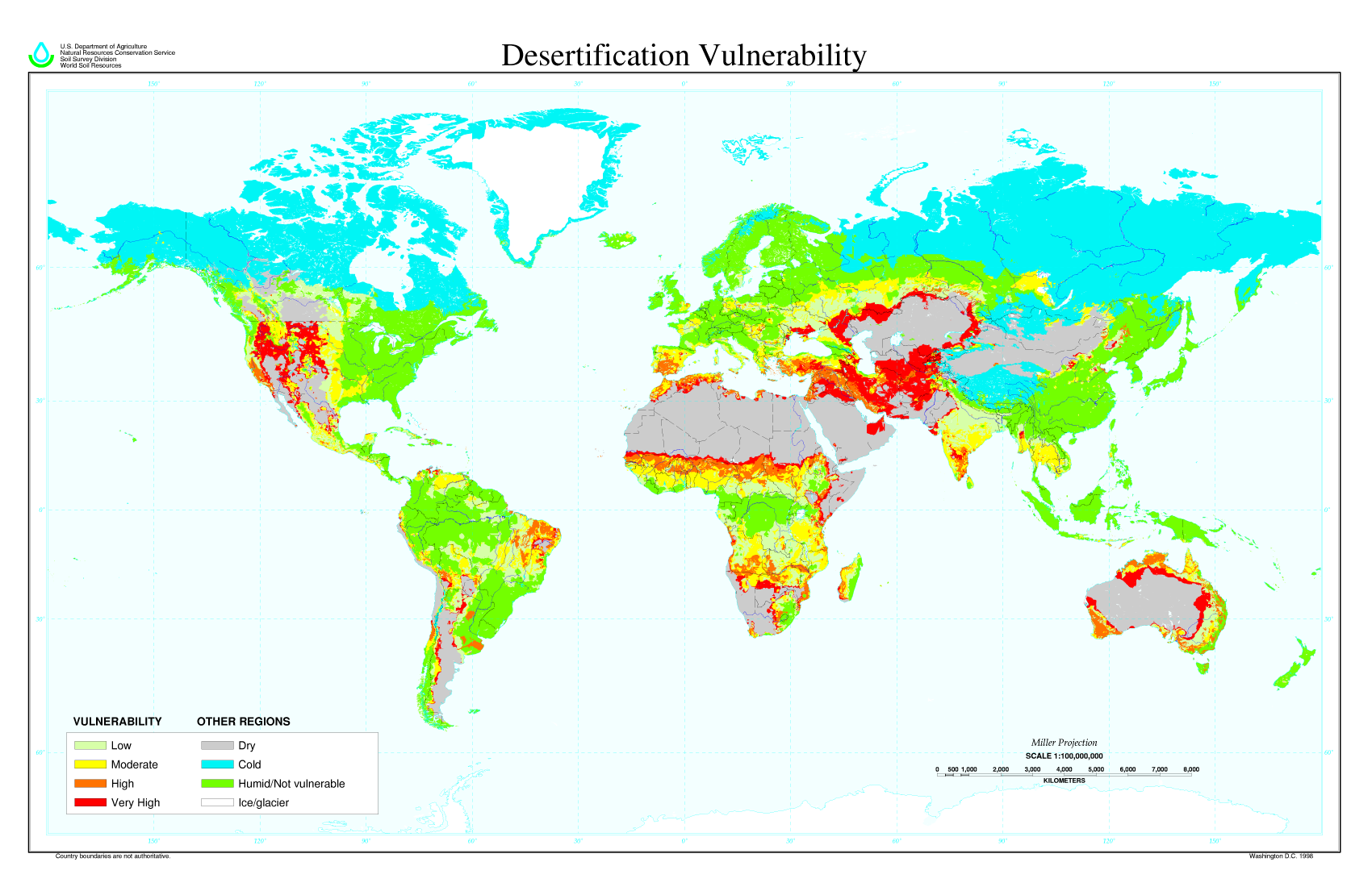
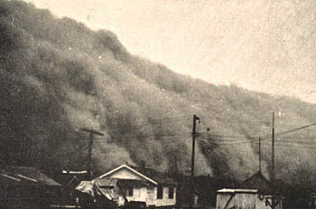
    Figure \(\PageIndex{b}\) shows areas of the world and their vulnerability to desertification. Note the red and orange areas in the western and midwestern United States. The Dust Bowl of the 1930s is a classic example of human-caused desertification (figure \(\PageIndex{c}\)). Poor cultivation and grazing practices -- coupled with severe drought conditions -- led to severe wind erosion of soil in a region of the Great Plains that became known as the "Dust Bowl". Wind stripped large areas of farmlands of topsoil, and formed clouds of dust that traveled as far as the eastern United States. 

    Sometimes there is a conflict between what is known to prevent desertification and what an individual farmer feels is needed to do to make a living. Mitigating the desertification process includes both societal steps and individual education on alternatives.

    World map showing the western U.S., and parts of Africa, the middle East, and Australia at high risks of desertification
    Figure \(\PageIndex{b}\): World map showing desertification vulnerability. There are four levels of vulnerability: very high (red), high (orange), moderate (yellow), and low (light green). Examples of regions with a very high vulnerability to desertification include the northwestern United States, a strip through western and central Africa, parts of the middle East, and parts of Australia. Examples of regions with low vulnerability include parts of Canada, parts of western Europe, and parts of Angola and the Democratic Republic of Congo. Other regions are labeled as dry (gray), cold (light blue), humid/not vulnerable (bright green), or ice/glacier (white). For example, northern regions are cold and ice/glacier. Some of southwestern United States, Chile and Argentina, northern Africa, the Middle East, Kazakhstan, Mongolia, and much of Australia are considered dry. Examples of humid/not vulnerable areas include the eastern United States, northern and eastern South America, western Europe, Central Africa, and East Asia. Image by USDA (public domain).
    A wall of dust approaches a Kansas town, as shown in this black and white photo.
    Figure \(\PageIndex{c}\): A cloud of dust in Kansas in 1935, part of the Dust Bowl. Image by NOAA Photo Library (public domain).

    Attribution

    Modified by Melissa Ha from the following sources:


    This page titled 13.4: Soil Degradation is shared under a CC BY-NC-SA license and was authored, remixed, and/or curated by Melissa Ha and Rachel Schleiger (ASCCC Open Educational Resources Initiative) .