
6.1: Climate and Biomes
- Page ID
- 70823

\( \newcommand{\vecs}[1]{\overset { \scriptstyle \rightharpoonup} {\mathbf{#1}} } \)
\( \newcommand{\vecd}[1]{\overset{-\!-\!\rightharpoonup}{\vphantom{a}\smash {#1}}} \)
\( \newcommand{\dsum}{\displaystyle\sum\limits} \)
\( \newcommand{\dint}{\displaystyle\int\limits} \)
\( \newcommand{\dlim}{\displaystyle\lim\limits} \)
\( \newcommand{\id}{\mathrm{id}}\) \( \newcommand{\Span}{\mathrm{span}}\)
( \newcommand{\kernel}{\mathrm{null}\,}\) \( \newcommand{\range}{\mathrm{range}\,}\)
\( \newcommand{\RealPart}{\mathrm{Re}}\) \( \newcommand{\ImaginaryPart}{\mathrm{Im}}\)
\( \newcommand{\Argument}{\mathrm{Arg}}\) \( \newcommand{\norm}[1]{\| #1 \|}\)
\( \newcommand{\inner}[2]{\langle #1, #2 \rangle}\)
\( \newcommand{\Span}{\mathrm{span}}\)
\( \newcommand{\id}{\mathrm{id}}\)
\( \newcommand{\Span}{\mathrm{span}}\)
\( \newcommand{\kernel}{\mathrm{null}\,}\)
\( \newcommand{\range}{\mathrm{range}\,}\)
\( \newcommand{\RealPart}{\mathrm{Re}}\)
\( \newcommand{\ImaginaryPart}{\mathrm{Im}}\)
\( \newcommand{\Argument}{\mathrm{Arg}}\)
\( \newcommand{\norm}[1]{\| #1 \|}\)
\( \newcommand{\inner}[2]{\langle #1, #2 \rangle}\)
\( \newcommand{\Span}{\mathrm{span}}\) \( \newcommand{\AA}{\unicode[.8,0]{x212B}}\)
\( \newcommand{\vectorA}[1]{\vec{#1}} % arrow\)
\( \newcommand{\vectorAt}[1]{\vec{\text{#1}}} % arrow\)
\( \newcommand{\vectorB}[1]{\overset { \scriptstyle \rightharpoonup} {\mathbf{#1}} } \)
\( \newcommand{\vectorC}[1]{\textbf{#1}} \)
\( \newcommand{\vectorD}[1]{\overrightarrow{#1}} \)
\( \newcommand{\vectorDt}[1]{\overrightarrow{\text{#1}}} \)
\( \newcommand{\vectE}[1]{\overset{-\!-\!\rightharpoonup}{\vphantom{a}\smash{\mathbf {#1}}}} \)
\( \newcommand{\vecs}[1]{\overset { \scriptstyle \rightharpoonup} {\mathbf{#1}} } \)
\(\newcommand{\longvect}{\overrightarrow}\)
\( \newcommand{\vecd}[1]{\overset{-\!-\!\rightharpoonup}{\vphantom{a}\smash {#1}}} \)
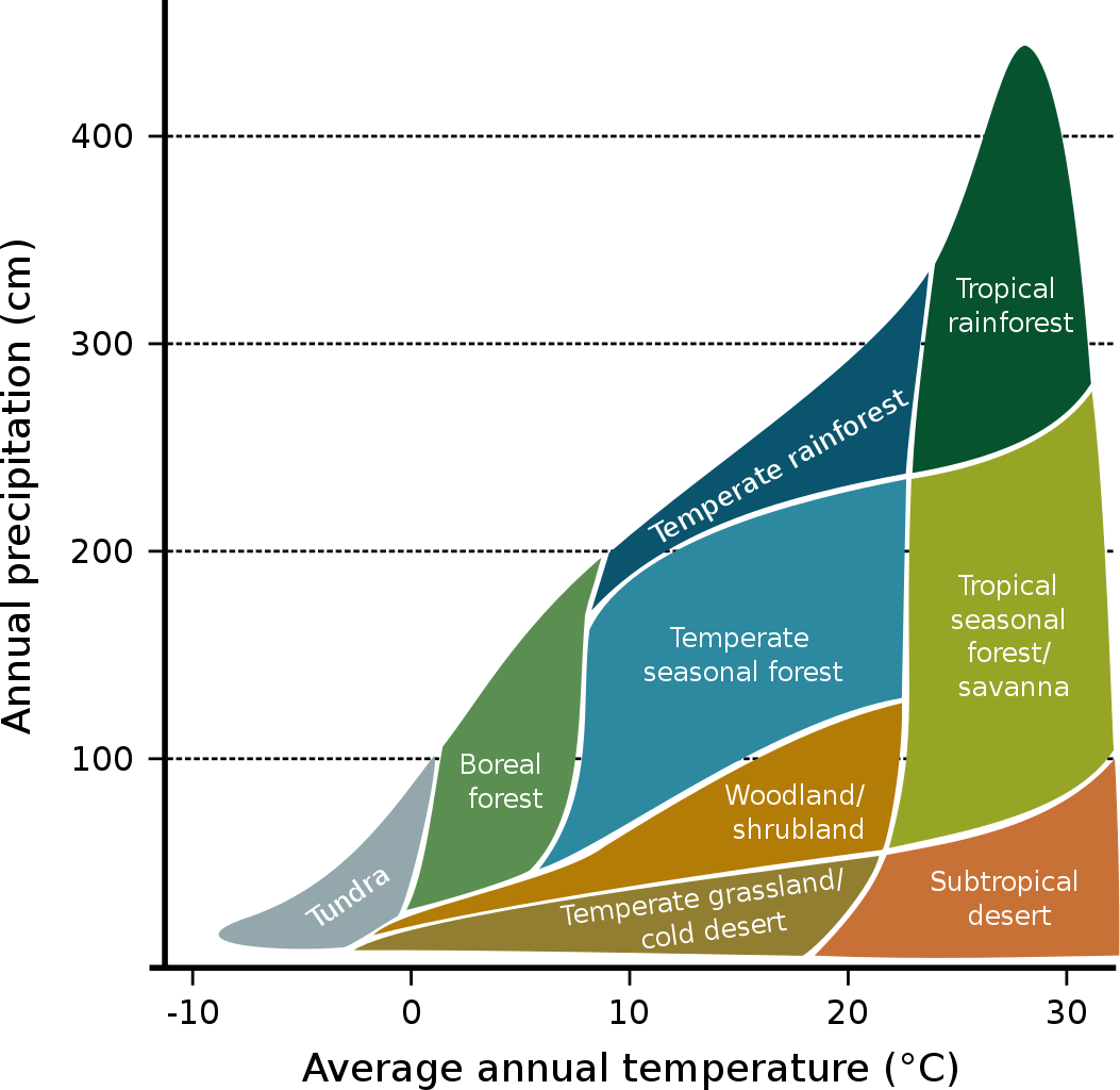
\(\newcommand{\avec}{\mathbf a}\) \(\newcommand{\bvec}{\mathbf b}\) \(\newcommand{\cvec}{\mathbf c}\) \(\newcommand{\dvec}{\mathbf d}\) \(\newcommand{\dtil}{\widetilde{\mathbf d}}\) \(\newcommand{\evec}{\mathbf e}\) \(\newcommand{\fvec}{\mathbf f}\) \(\newcommand{\nvec}{\mathbf n}\) \(\newcommand{\pvec}{\mathbf p}\) \(\newcommand{\qvec}{\mathbf q}\) \(\newcommand{\svec}{\mathbf s}\) \(\newcommand{\tvec}{\mathbf t}\) \(\newcommand{\uvec}{\mathbf u}\) \(\newcommand{\vvec}{\mathbf v}\) \(\newcommand{\wvec}{\mathbf w}\) \(\newcommand{\xvec}{\mathbf x}\) \(\newcommand{\yvec}{\mathbf y}\) \(\newcommand{\zvec}{\mathbf z}\) \(\newcommand{\rvec}{\mathbf r}\) \(\newcommand{\mvec}{\mathbf m}\) \(\newcommand{\zerovec}{\mathbf 0}\) \(\newcommand{\onevec}{\mathbf 1}\) \(\newcommand{\real}{\mathbb R}\) \(\newcommand{\twovec}[2]{\left[\begin{array}{r}#1 \\ #2 \end{array}\right]}\) \(\newcommand{\ctwovec}[2]{\left[\begin{array}{c}#1 \\ #2 \end{array}\right]}\) \(\newcommand{\threevec}[3]{\left[\begin{array}{r}#1 \\ #2 \\ #3 \end{array}\right]}\) \(\newcommand{\cthreevec}[3]{\left[\begin{array}{c}#1 \\ #2 \\ #3 \end{array}\right]}\) \(\newcommand{\fourvec}[4]{\left[\begin{array}{r}#1 \\ #2 \\ #3 \\ #4 \end{array}\right]}\) \(\newcommand{\cfourvec}[4]{\left[\begin{array}{c}#1 \\ #2 \\ #3 \\ #4 \end{array}\right]}\) \(\newcommand{\fivevec}[5]{\left[\begin{array}{r}#1 \\ #2 \\ #3 \\ #4 \\ #5 \\ \end{array}\right]}\) \(\newcommand{\cfivevec}[5]{\left[\begin{array}{c}#1 \\ #2 \\ #3 \\ #4 \\ #5 \\ \end{array}\right]}\) \(\newcommand{\mattwo}[4]{\left[\begin{array}{rr}#1 \amp #2 \\ #3 \amp #4 \\ \end{array}\right]}\) \(\newcommand{\laspan}[1]{\text{Span}\{#1\}}\) \(\newcommand{\bcal}{\cal B}\) \(\newcommand{\ccal}{\cal C}\) \(\newcommand{\scal}{\cal S}\) \(\newcommand{\wcal}{\cal W}\) \(\newcommand{\ecal}{\cal E}\) \(\newcommand{\coords}[2]{\left\{#1\right\}_{#2}}\) \(\newcommand{\gray}[1]{\color{gray}{#1}}\) \(\newcommand{\lgray}[1]{\color{lightgray}{#1}}\) \(\newcommand{\rank}{\operatorname{rank}}\) \(\newcommand{\row}{\text{Row}}\) \(\newcommand{\col}{\text{Col}}\) \(\renewcommand{\row}{\text{Row}}\) \(\newcommand{\nul}{\text{Nul}}\) \(\newcommand{\var}{\text{Var}}\) \(\newcommand{\corr}{\text{corr}}\) \(\newcommand{\len}[1]{\left|#1\right|}\) \(\newcommand{\bbar}{\overline{\bvec}}\) \(\newcommand{\bhat}{\widehat{\bvec}}\) \(\newcommand{\bperp}{\bvec^\perp}\) \(\newcommand{\xhat}{\widehat{\xvec}}\) \(\newcommand{\vhat}{\widehat{\vvec}}\) \(\newcommand{\uhat}{\widehat{\uvec}}\) \(\newcommand{\what}{\widehat{\wvec}}\) \(\newcommand{\Sighat}{\widehat{\Sigma}}\) \(\newcommand{\lt}{<}\) \(\newcommand{\gt}{>}\) \(\newcommand{\amp}{&}\) \(\definecolor{fillinmathshade}{gray}{0.9}\)Biomes are large-scale environments that are distinguished by characteristic climate and vegetation (figure \(\PageIndex{a}\)). Biomes are also characterized by the animals and other organisms there, which are influenced by vegetation and climate patterns. The Earth’s biomes are categorized into two major groups: terrestrial and aquatic. Terrestrial biomes are based on land, while aquatic biomes include both ocean and freshwater biomes. Altitude and latitude, which affect temperature and precipitation determine the distribution of biomes.
Low latitudes (near the equator) have high temperatures, while high latitudes (near the poles) have low temperatures. This is because the sun hits the equator more directly. Sunlight hits the poles at an angle, reducing the intensity of light (and heat energy) per unit of area. Temperature also decreases with altitude. At high altitudes, the atmosphere is thinner and traps less heat energy from the sun. Because temperatures decline with altitude as well as latitude, similar biomes exist on mountains even when they are at low latitudes. As a rule of thumb, a climb of 1000 feet (about 300 m) is equivalent in changed flora and fauna to a trip northward of some 600 miles (966 km).
Where precipitation is moderately abundant — 40 inches (about 1 m) or more per year — and distributed fairly evenly throughout the year, the major determinant is temperature. It is not simply a matter of average temperature, but includes such limiting factors as whether it ever freezes or length of the growing season. Biomes are thus characterized not only by average temperature and precipitation but also their seasonality.
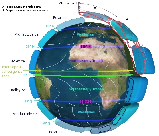
Not only does latitude influence temperature, but it also affects precipitation. For example, deserts tend to occur at latitudes of around 30° and at the poles, both north and south, driven by circulation and prevailing wind patterns in the atmosphere. The engine that drives circulation in the atmosphere and oceans is solar energy, which is determined by the average position of the sun over the Earth’s surface. Direct light provides uneven heating depending on latitude and angle of incidence, with high solar energy in the tropics, and little or no energy at the poles. Atmospheric circulation and geographic location are the primary causal agents of deserts. At approximately 30° north and south of the equator, sinking air produces trade wind deserts like the Sahara and the Outback of Australia (figure \(\PageIndex{b}\)).
The MinuteEarth video below discusses the global climate patterns which lead to deserts.
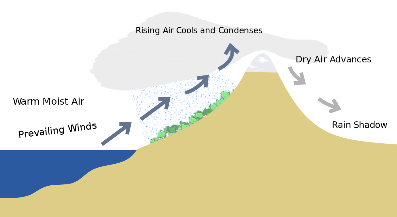
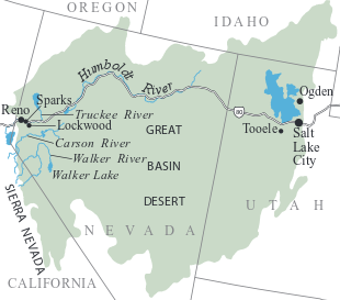
Rainshadow deserts are produced where prevailing winds with moist air dries as it is forced to rise over mountains. The prevailing winds in the western half of North America blow in from the Pacific laden with moisture. Each time this air rises up from the western slopes of, successively, the Coast Ranges, the Sierras and Cascades, and finally the Rockies, it cools and its capacity to hold moisture decreases. The excess moisture condenses to rain or snow, which drenches the mountain slopes beneath. When the air reaches the eastern slopes, it is relatively dry, and much less precipitation falls. This phenomenon is called the rainshadow effect (figure \(\PageIndex{c}\)). How much rain falls and when influences the type of biome. For example, the Great Basin Desert (figure \(\PageIndex{d}\)) is a rain shadow desert produced as moist air from the Pacific rises by lifting over the Sierra Nevada Mountain (and other) and loses moisture from previous condensation and precipitation on the rainy side of the range(s).
Attributions
Modified by Melissa Ha from the following sources:
- Biomes from Biology by John W. Kimball (licensed under CC-BY)
- Prelude to Deserts and The Origin of Deserts from An Introduction to Geology by Chris Johnson et al. (licensed under CC BY-NC-SA)
- Community Ecology and Terrestrial Biomes from Environmental Biology by Matthew R. Fisher (licensed under CC-BY)
- Terrestrial Biomes from Biology 2e by OpenStax (CC-BY). Access for free at openstax.org.