
21.1: What is Landscape Ecology?
- Page ID
- 92908
\( \newcommand{\vecs}[1]{\overset { \scriptstyle \rightharpoonup} {\mathbf{#1}} } \)
\( \newcommand{\vecd}[1]{\overset{-\!-\!\rightharpoonup}{\vphantom{a}\smash {#1}}} \)
\( \newcommand{\id}{\mathrm{id}}\) \( \newcommand{\Span}{\mathrm{span}}\)
( \newcommand{\kernel}{\mathrm{null}\,}\) \( \newcommand{\range}{\mathrm{range}\,}\)
\( \newcommand{\RealPart}{\mathrm{Re}}\) \( \newcommand{\ImaginaryPart}{\mathrm{Im}}\)
\( \newcommand{\Argument}{\mathrm{Arg}}\) \( \newcommand{\norm}[1]{\| #1 \|}\)
\( \newcommand{\inner}[2]{\langle #1, #2 \rangle}\)
\( \newcommand{\Span}{\mathrm{span}}\)
\( \newcommand{\id}{\mathrm{id}}\)
\( \newcommand{\Span}{\mathrm{span}}\)
\( \newcommand{\kernel}{\mathrm{null}\,}\)
\( \newcommand{\range}{\mathrm{range}\,}\)
\( \newcommand{\RealPart}{\mathrm{Re}}\)
\( \newcommand{\ImaginaryPart}{\mathrm{Im}}\)
\( \newcommand{\Argument}{\mathrm{Arg}}\)
\( \newcommand{\norm}[1]{\| #1 \|}\)
\( \newcommand{\inner}[2]{\langle #1, #2 \rangle}\)
\( \newcommand{\Span}{\mathrm{span}}\) \( \newcommand{\AA}{\unicode[.8,0]{x212B}}\)
\( \newcommand{\vectorA}[1]{\vec{#1}} % arrow\)
\( \newcommand{\vectorAt}[1]{\vec{\text{#1}}} % arrow\)
\( \newcommand{\vectorB}[1]{\overset { \scriptstyle \rightharpoonup} {\mathbf{#1}} } \)
\( \newcommand{\vectorC}[1]{\textbf{#1}} \)
\( \newcommand{\vectorD}[1]{\overrightarrow{#1}} \)
\( \newcommand{\vectorDt}[1]{\overrightarrow{\text{#1}}} \)
\( \newcommand{\vectE}[1]{\overset{-\!-\!\rightharpoonup}{\vphantom{a}\smash{\mathbf {#1}}}} \)
\( \newcommand{\vecs}[1]{\overset { \scriptstyle \rightharpoonup} {\mathbf{#1}} } \)
\( \newcommand{\vecd}[1]{\overset{-\!-\!\rightharpoonup}{\vphantom{a}\smash {#1}}} \)
Introduction
Landscape ecology is the study of the pattern and interaction between ecosystems within a region of interest, and the way the interactions affect ecological processes, especially the unique effects of spatial heterogeneity on these interactions. This is done within a variety of landscape scales, development spatial patterns, and organizational levels of research and policy. Concisely, landscape ecology can be described as the science of landscape diversity as the synergetic result of biodiversity and geodiversity.
As a highly interdisciplinary field in systems science, landscape ecology integrates biophysical and analytical approaches with humanistic and holistic perspectives across the natural sciences and social sciences. Landscapes are spatially heterogeneous geographic areas characterized by diverse interacting patches or ecosystems, ranging from relatively natural terrestrial and aquatic systems such as forests, grasslands, and lakes to human-dominated environments including agricultural and urban settings.
The most salient characteristics of landscape ecology are its emphasis on the relationship among pattern, process, and scale, and its focus on broad-scale ecological and environmental issues. These necessitate the coupling between biophysical and socioeconomic sciences. Key research topics in landscape ecology include ecological flows in landscape mosaics, land use and land cover change, scaling, relating landscape pattern analysis with ecological processes, and landscape conservation and sustainability. Landscape ecology also studies the role of human impacts on landscape diversity in the development and spreading of new human pathogens that could trigger epidemics.
Heterogeneity is the measure of how parts of a landscape differ from one another. Landscape ecology looks at how this spatial structure affects organism abundance at the landscape level, as well as the behavior and functioning of the landscape as a whole. This includes studying the influence of pattern, or the internal order of a landscape, on process, or the continuous operation of functions of organisms. Landscape ecology also includes geomorphology as applied to the design and architecture of landscapes. Geomorphology is the study of how geological formations are responsible for the structure of a landscape.
Terminology and Concepts
Scale and Heterogeneity
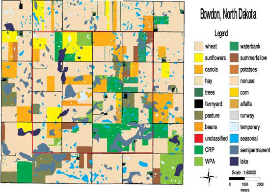
Imaging and mapping technology naturally promoted a patch-corridor-matrix approach to landscape ecology (Figure \(\PageIndex{1}\)). Examining the map of an area in North Dakota (Figure \(\PageIndex{2}\)) helps to define important vocabulary and illustrates some typical questions studied by landscape ecologists. A patch is an area of habitat differing from its surroundings, often the smallest ecologically distinct landscape feature in a landscape mapping and classification system. In Figure \(\PageIndex{2}\), wetlands and perennial grasslands would likely be patches of focal interest for the study of ecological processes. The matrix is the majority of the surrounding landscape (i.e., not the patches); in this case the matrix primarily consists of fields of agricultural crops. The large proportion of the landscape classified as matrix may have profound influences on the ecological processes in the landscape; for example, consider the flow of pesticides from the farmed matrix to the wetland patches in Figure \(\PageIndex{2}\). Finally, corridors are narrow patches that may act as links or barriers in a landscape. Beyond the image of narrow patches, corridors are functionally important landscape structures influencing dispersal of plants and animals in the landscape.

Composition and Patches
Composition is the relative proportion of habitat types in the landscape, regardless of spatial distribution; for example, in Figure \(\PageIndex{2}\) perennial grasslands comprise 17%, wetlands about 18%, and croplands about 56% of the landscape. Configuration refers to almost limitless aspects of landscape heterogeneity, especially the physical and spatial distribution of landscape elements. Configuration metrics that apply across an entire landscape would include characteristics such as the dendritic pattern of streams in a watershed, or the diversity of habitat types. Ecologists have been particularly interested in how the spatial distribution of elements affects ecological processes. For example, “is the percentage of wetlands occupied by tiger salamanders (Ambystoma tigrinum) influenced by whether wetlands are distributed randomly or clumped to some degree?” (Figure \(\PageIndex{2}\)). Another sense of configuration focuses on the characteristics of patches (e.g., the size, shape, or perimeter to area ratio [P/A] of individual patches). This latter emphasis is often prompted by interest in a particular organism that uses a patch type as habitat (e.g., grassland birds nesting in the landscape) (Figure \(\PageIndex{2}\)). P/A is a measure of the amount of edge (or ecotone) between a focal patch type and the surrounding matrix. Ecotones represent transitional zones that often have important influences on ecological processes. In Figure \(\PageIndex{2}\), landscape ecologists have asked, “do predators search for nests in the same patterns along edges compared to interiors of grassland patches?”.
There are many other terms (see below) and metrics that are used to describe landscapes, but two others are particularly important to understand. In an ecological sense scale is the resolution at which an organism perceives its environment (e.g., consider a mouse population versus a moose population). Scale is important to plants too; “what is the detectable limit over which seeds disperse from a plant?” Often scale is also used in a technological sense referring to the smallest area that can be resolved into a single type on the landscape. Spatial scale of remotely sensed vegetation may be as small as 0.5 m, although for large areas it is more typically 30 m, or greater. Extent is the extended range of study, or the area included within the landscape boundary, such as a national park or state.
Boundary and edge
Landscape patches have a boundary between them which can be defined or fuzzy. The zone composed of the edges of adjacent ecosystems is the boundary. Edge means the portion of an ecosystem near its perimeter, where influences of the adjacent patches can cause an environmental difference between the interior of the patch and its edge. This edge effect includes a distinctive species composition or abundance. For example, when a landscape is a mosaic of perceptibly different types, such as a forest adjacent to a grassland, the edge is the location where the two types adjoin. In a continuous landscape, such as a forest giving way to open woodland, the exact edge location is fuzzy and is sometimes determined by a local gradient exceeding a threshold, such as the point where the tree cover falls below thirty-five percent.
Ecotones, ecoclines, and ecotopes
A type of boundary is the ecotone, or the transitional zone between two communities.Ecotones can arise naturally, such as a lakeshore, or can be human-created, such as a cleared agricultural field from a forest. The ecotonal community retains characteristics of each bordering community and often contains species not found in the adjacent communities. Classic examples of ecotones include fencerows, forest to marshlands transitions, forest to grassland transitions, or land-water interfaces such as riparian zones in forests. Characteristics of ecotones include vegetational sharpness, physiognomic change, occurrence of a spatial community mosaic, many exotic species, ecotonal species, spatial mass effect, and species richness higher or lower than either side of the ecotone.
An ecocline is another type of landscape boundary, but it is a gradual and continuous change in environmental conditions of an ecosystem or community. Ecoclines help explain the distribution and diversity of organisms within a landscape because certain organisms survive better under certain conditions, which change along the ecocline. They contain heterogeneous communities which are considered more environmentally stable than those of ecotones. An ecotope is a spatial term representing the smallest ecologically distinct unit in mapping and classification of landscapes. Relatively homogeneous, they are spatially explicit landscape units used to stratify landscapes into ecologically distinct features. They are useful for the measurement and mapping of landscape structure, function, and change over time, and to examine the effects of disturbance and fragmentation.
.jpg?revision=1)
Figure \(\PageIndex{3}\): An ecotone between grassland and woodland (source: https://commons.wikimedia.org/wiki/F...967532722).jpg)
Disturbance and fragmentation
Disturbance is an event that significantly alters the pattern of variation in the structure or function of a system. Fragmentation is the breaking up of a habitat, ecosystem, or land-use type into smaller parcels.Disturbance is generally considered a natural process. Fragmentation causes land transformation, an important process in landscapes as development occurs.
An important consequence of repeated, random clearing (whether by natural disturbance or human activity) is that contiguous cover can break down into isolated patches. This happens when the area cleared exceeds a critical level, which means that landscapes exhibit two phases: connected and disconnected.

Figure \(\PageIndex{4}\): Rapid deforestation in Cambodia resulted in habitat loss and fragmentation (Global Forest Watch. World Resources Institute. Accessed on 1/5/2022. www.globalforestwatch.org)
History
Throughout the history of ecology, scientists have observed variability across time and space in the abiotic and biotic components of ecosystems. But early ecologists did not have the technology or concepts to explicitly deal with spatial heterogeneity, so there was a tendency to develop explanations by grouping organisms into uniform and recognizable units. For example, scientists were struck by the relatively consistent associations of plant species and grouped vegetation into community types (Mueller-Dombois & Ellenberg 1974). Compared to vegetation, where observed change was rather slow, observations of fluctuating populations ranging from bacteria and protozoans in the laboratory to snowshoe hares (Lepus americanus) in the boreal forest, led scientists to mathematical theories that explicitly focused on temporal dynamics (Kingsland 1995). But the resulting models treated the environment as spatially homogeneous. Such views of nature and the theory about dynamics led to “equilibrium” concepts (May 1973) that dominated ecological thinking from the 1920s through the 1980s.
During the 1980s, advances in the accessibility of computing, remotely sensed satellite and aerial imagery, development of geographic information systems (GIS, ARC/INFO was first released in 1982), and spatial statistical methods (Fortin & Dale 2005), enabled ecologists to observe and analyze spatial heterogeneity ranging from local habitats to entire continents. The technology enhanced a paradigm shift occurring in ecology and the emergence of landscape ecology as a sub-discipline within ecology (Wu & Loucks 1995). Landscape ecology specifically recognizes that disturbance, whether anthropogenic or caused by natural processes, creates spatial heterogeneity that is the normal condition of ecosystems. In landscape ecology particularly, a “non-equilibrium” view emerged, that links disturbance in time and space to system structure and function in feedback loops that influence the ecology and evolutionary trajectories in the ecosystems. The International Association of Landscape Ecology was formed in 1982. In 1986, Forman and Godron published their seminal text on landscape ecology. This work was important, not only because it outlined principles, but also because it brought together the North American scientific interest — typically focused on heterogeneity in ecosystems — with more anthropocentric scientific traditions of geography, landscape architecture, and planning, rooted in the long history of landscape alteration in Europe.
One central landscape ecology theory originated from MacArthur & Wilson's The Theory of Island Biogeography (see 21.3). The concepts of island biogeography were generalized from physical islands to abstract patches of habitat. This generalization spurred the growth of landscape ecology by providing conservation biologists a new tool to assess how habitat fragmentation affects population viability. Recent growth of landscape ecology owes much to the development of geographic information systems (GIS) and the availability of large-extent habitat data (e.g. remotely sensed datasets) Figure \(\PageIndex{1}\).
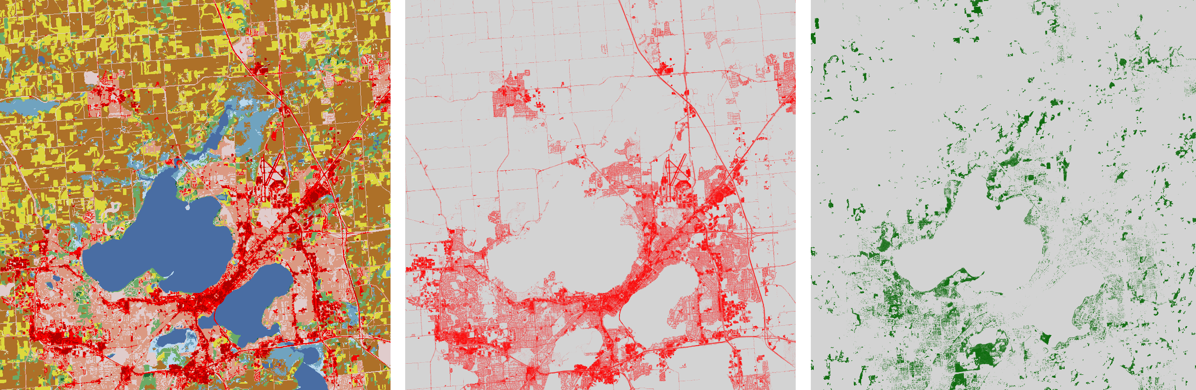
Figure \(\PageIndex{1}\): Land cover surrounding Madison, WI. Left: fields are colored yellow and brown, water is colored blue, and urban surfaces are colored red. Center: impervious surfaces. Right: canopy cover.
Development as a discipline
Today, the theory and application of landscape ecology continue to develop through a need for innovative applications in a changing landscape and environment. Landscape ecology relies on advanced technologies such as remote sensing, GIS, and models. There has been associated development of powerful quantitative methods to examine the interactions of patterns and processes. An example would be determining the amount of carbon present in the soil based on landform over a landscape, derived from GIS maps, vegetation types, and rainfall data for a region. Remote sensing work has been used to extend landscape ecology to the field of predictive vegetation mapping.