
13.1: Fresh Water Supply and the Water Cycle
- Page ID
- 31652

Water, air, and food are the most important natural resources to people. Humans can live only a few minutes without oxygen, less than a week without water, and about a month without food. Water also is essential for our oxygen and food supply. Plants breakdown water and use it to create oxygen during the process of photosynthesis.
Human babies are approximately 75% water, and adults are 60% water. Our brain is about 85% water, blood and kidneys are 83% water, muscles are 76% water, and even bones are 22% water. We constantly lose water by perspiration. In temperate climates we should drink about two quarts of water per day, and people in hot desert climates should drink up to 10 quarts of water per day. Loss of 15% of body-water usually causes death.
Water Reservoirs
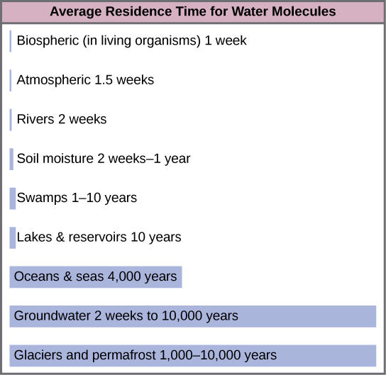
Water is the only common substance that occurs naturally on Earth in three forms: solid, liquid and gas. The hydrosphere is the area of Earth where water movement and water storage occurs. Water reservoirs are the locations where water is stored. (Note that this term can also refer to artificial lakes created by dams.) Water is found as a liquid on the surface (rivers, lakes, oceans) and beneath the surface (groundwater), as ice (polar ice caps and glaciers), and as water vapor in the atmosphere. Figure \(\PageIndex{a}\) illustrates the average time that an individual water molecule may spend in the Earth’s major water reservoirs. Residence time is a measure of the average time an individual water molecule stays in a particular reservoir.
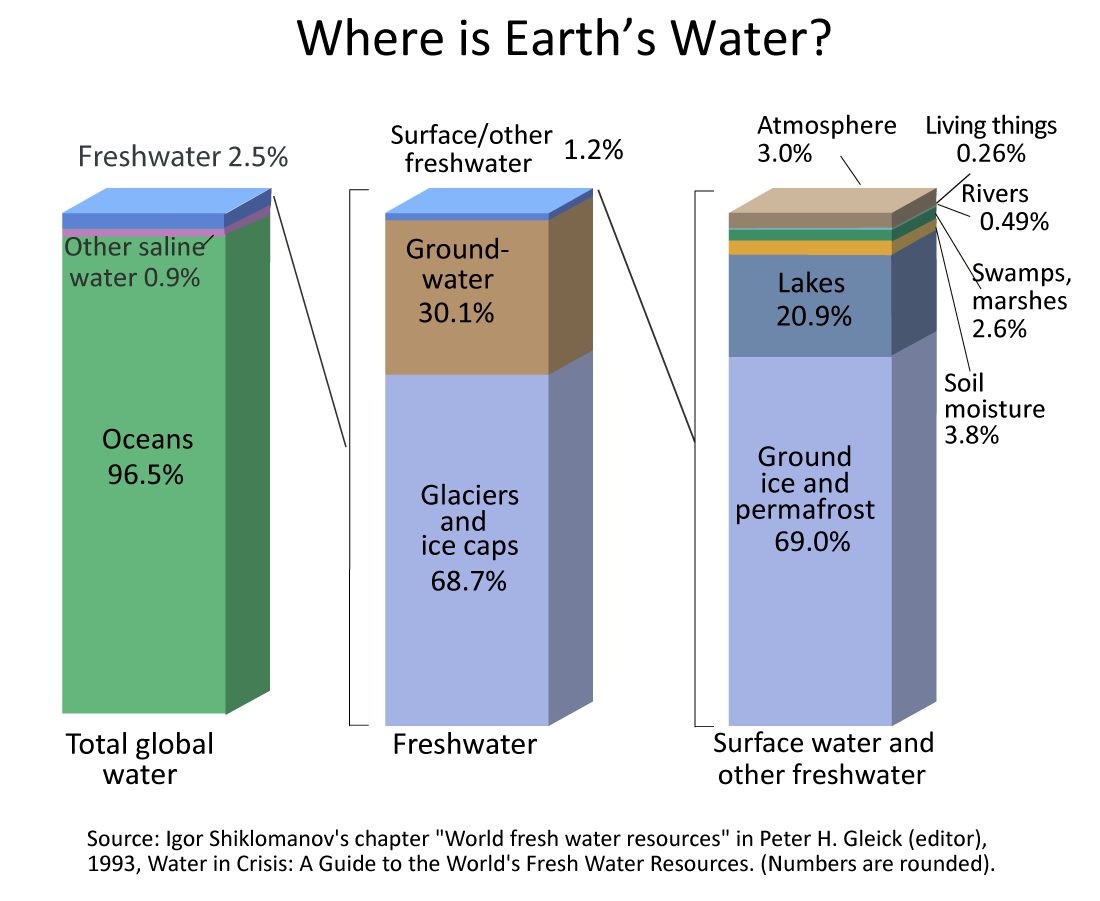
Earth is truly the Water Planet. The abundance of liquid water on Earth’s surface distinguishes us from other bodies in the solar system. About 71% of Earth’s surface is covered by water, and approximately half of Earth’s surface is obscured by clouds (also made of water) at any time. There is a very large volume of water on our planet, about 1.4 billion cubic kilometers (km3) = 330 million cubic miles, or about 53 billion gallons per person on Earth. All of Earth’s water could cover the United States to a depth of 145 km (90 mi).
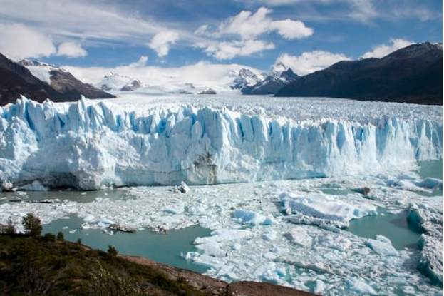
Despite the vast volumes of water on Earth, only 2.5% is freshwater (figure \(\PageIndex{b}\)), and only 0.01% is available for humans to use. If all of world’s water was shrunk to the size of 1 gallon, then the total amount of fresh water would be about 1/3 cup, and the amount of readily usable freshwater would be 2-3 tablespoons. Much of Earth's freshwater is trapped in glaciers and polar ice caps (figure \(\PageIndex{c}\)), and this water is inconveniently located, mostly in Antarctica and Greenland. Shallow groundwater (water located below the Earth's surface) is the largest reservoir of usable fresh water. Many organisms are dependent on surface waters, such as lakes and rivers, which comprise a small fraction of freshwater on Earth. A lack of these surface waters can have negative effects on ecosystems.
The Water Cycle
The water cycle (hydrologic cycle) shows the movement of water through different reservoirs, which include oceans, atmosphere, glaciers, groundwater, lakes, rivers, and organisms (figure \(\PageIndex{d}\)). Solar energy, which warms the oceans and other surface waters, and gravity drive the motion of water in the water cycle. This leads to evaporation (liquid water to water vapor) of liquid surface water, sublimation (ice to water vapor) of frozen water, and transpiration (the loss of water from plants to the atmosphere). When water in the soil is taken up by plant roots, it moves through tubes in the plant (the vascular system), evaporates within the space of the leaf, and transpires through the stomata (small microscope openings) of the leaves. Ecologists combine transpiration and evaporation into a single term that describes water returned to the atmosphere: evapotranspiration. Thus, large amounts of water move into the atmosphere as water vapor.
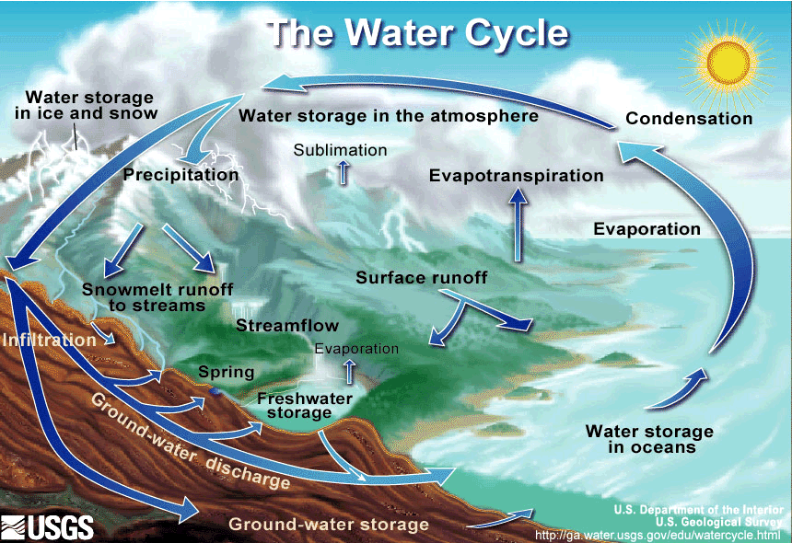
Water vapor in the atmosphere can migrate long-distances from ocean to over land by way of prevailing winds. Over the ocean or land, the air can cool and cause the water to condense back into liquid water. This usually happens in the form of very small water droplets that form around a microscopic piece of dust or salt called condensation nuclei. These small water droplets are visible as a cloud. Clouds build and once the water droplets are big enough, they fall to earth as precipitation (rain, snow, hail, or sleet), which returns water to Earth’s surface.
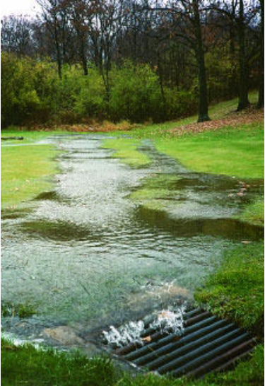
Precipitation that reaches land can immediately return to the atmosphere, add to groundwater, or form surface runoff. In most natural terrestrial environments, rain encounters vegetation before it reaches the soil surface. A significant percentage of water evaporates immediately from the surfaces of plants or directly from the soil surface. Groundwater is replenished when water infiltrates into the soil and finally fills the pore spaces between particles in dirt, sand, and gravel or in the fissures in rocks. Groundwater slowly moves through rock and unconsolidated materials and some of it eventually reaches the surface again, where it discharges as springs and into streams, lakes, and the ocean. Many streams flow not because they are replenished from rainwater directly but because they receive a constant inflow from the groundwater below. Also, surface water in streams and lakes can infiltrate again to recharge groundwater. Therefore, the surface water and groundwater systems are connected. Groundwater can also ultimately flow into the ocean through subsurface groundwater flow, but some groundwater is found very deep in the bedrock and can persist there for millennia. Surface runoff is the flow of freshwater over land either from rain or melting ice. Runoff can make its way through streams and lakes to the oceans. Surface runoff will occur only if the soil becomes saturated with water in a heavy rainfall.
The steps of the water cycle are explained in the video below.
Salinity and the Water Cycle
An important part of the water cycle is how water varies in salinity, which is the abundance of dissolved ions in water. The saltwater in the oceans is highly saline, with about 35,000 mg of dissolved ions per liter of seawater. Evaporation is a distillation process that produces nearly pure water with almost no dissolved ions. As water vaporizes, it leaves the dissolved ions in the original liquid phase. Eventually, condensation forms clouds and sometimes precipitation. After rainwater falls onto land, it dissolves minerals in rock and soil, which increases its salinity. Rain and surface runoff are major ways in which minerals, including phosphorus and sulfur, are cycled from land to water. The environmental effects of runoff were discussed in Biogeochemical Cycles. Freshwater (such as lakes, rivers, and near-surface groundwater) has a relatively low salinity.
Human Interactions with The Water Cycle
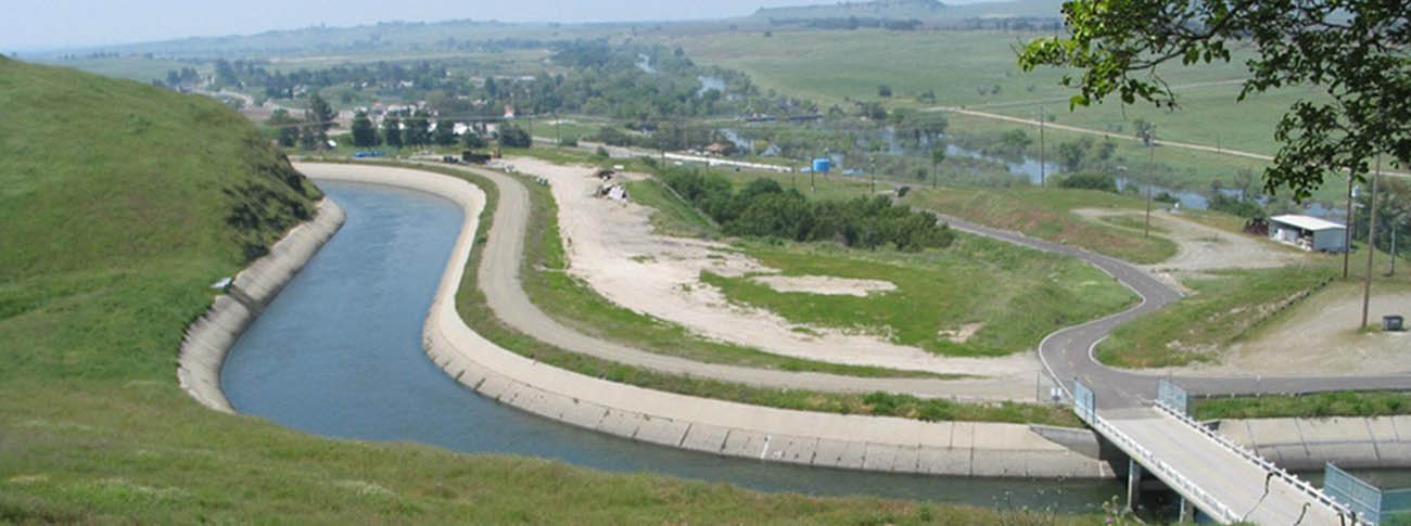
Humans alter the water cycle by extracting large amounts of freshwater from surface waters as well as groundwater (see Water Usage). Additionally, changes in land use, such as deforestation, agriculture, and urbanization, reduce vegetation cover, which reduces infiltration and increases surface runoff. (Vegetation naturally traps precipitation as it falls, slows the flow surface runoff, and increases the infiltration rate.) This intensifies flooding and exacerbates erosion, lowering soil quality and causing sediment pollution in water. Additionally, humans redirect the flow of water by building dams and aqueducts (figure \(\PageIndex{e}\)). So much water is removed or redirected from the Colorado River in the western United States that, despite its considerable size, in some years it is dry before reaching the sea in Mexico. In an extreme example, the Aral Sea in Central Asia has decreased to only 10% of its initial size after water was diverted for agriculture (see this case study for more details).
Water Resources
Freshwater resources are ultimately replenished by precipitation. This water can then be obtained from surface water, such as rivers and lakes, and from aquifers, which store groundwater.
Primary Freshwater Resources: Precipitation
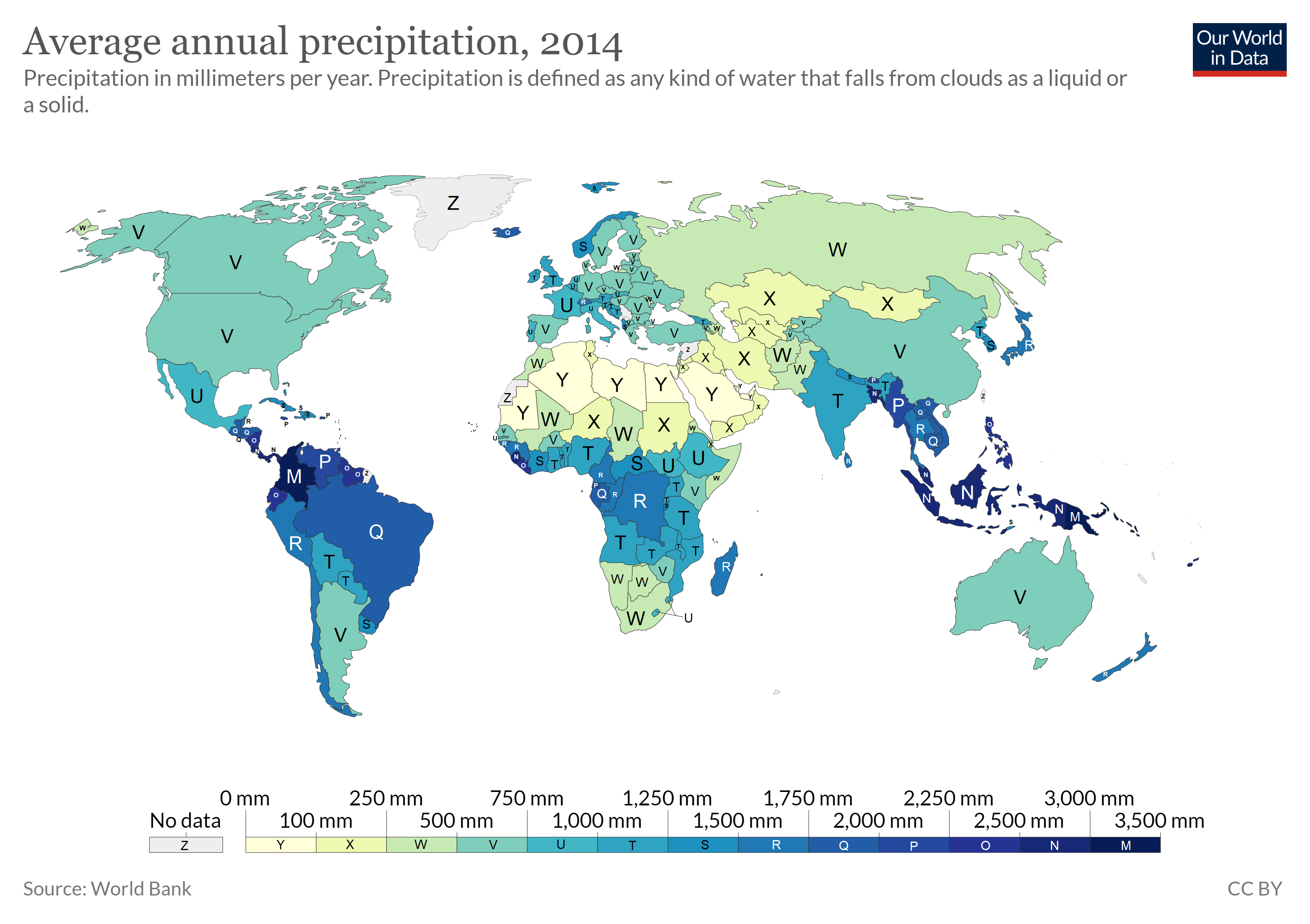
Precipitation levels are unevenly distributed around the globe, affecting fresh water availability (figure \(\PageIndex{f}\)). In general, due the uneven heating of the Earth and global air circulation cells resulting from the Earth's rotation, air rises near the equator and near 60° north and south latitude and sinks at the poles and 30° north and south latitude. As discussed in Climate Effects on Biomes, the intense sunlight at the equator heats air, causing it to rise and cool, which decreases the ability of the air mass to hold water vapor and results in frequent rainstorms. Around 30 degrees north and south latitude, descending air conditions produce warmer air, which increases its ability to hold water vapor and results in dry conditions. Both the dry air conditions and the warm temperatures of these latitude belts favor evaporation.
The size of continents, mountains, prevailing winds, ocean circulation patterns, and even the proximity of bodies of water can affect local climate patterns. For example, when cold winds blow across the relatively warm Great Salt Lake, the air warms, which causes it to pick up moisture. This local increase in the moisture content of the air may eventually fall as snow or rain on nearby mountains, a phenomenon known as “lake-effect precipitation”.
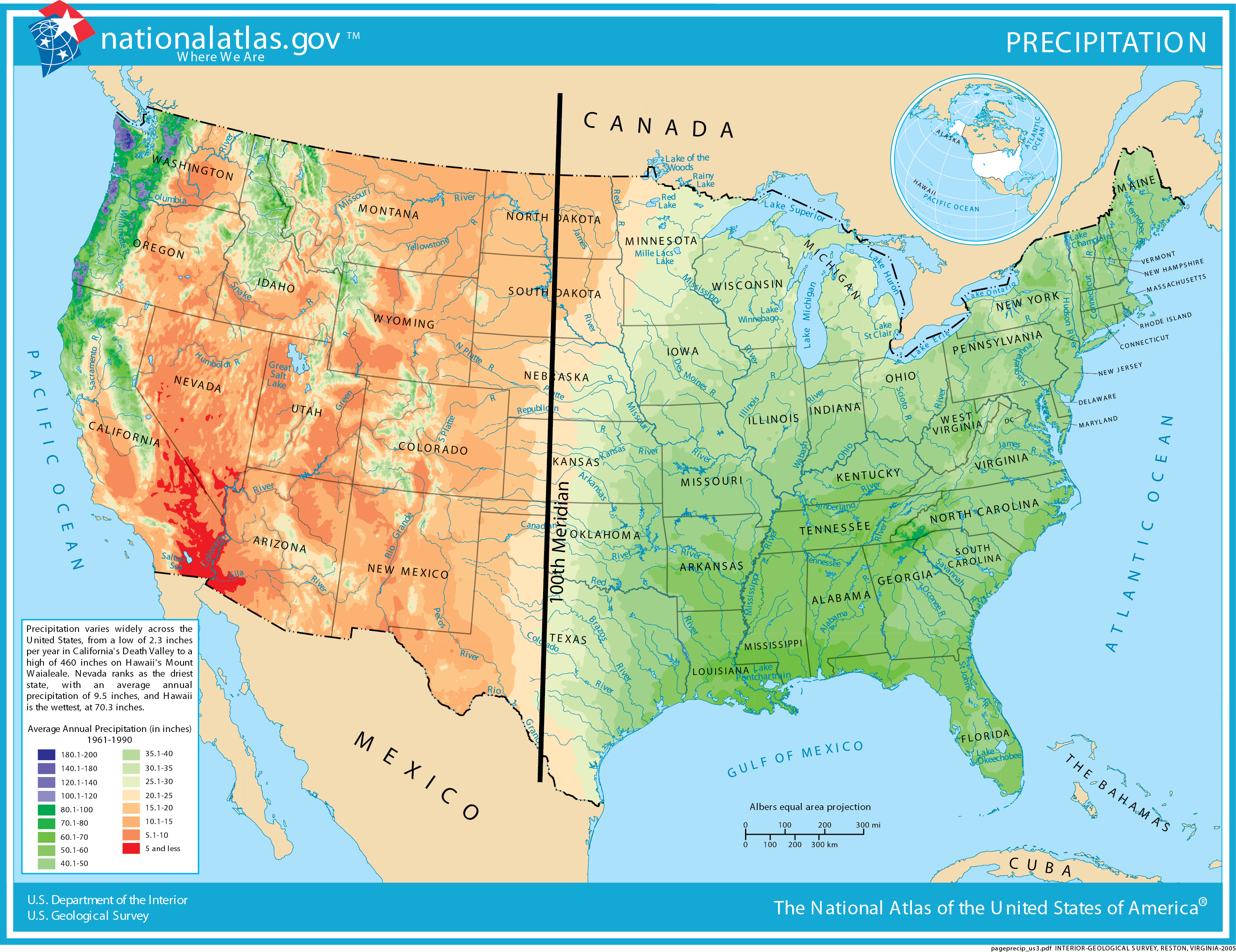
In the United States, the 100th Meridian roughly marks the boundary between the humid and arid parts of the country (figure \(\PageIndex{g}\)). Irrigation is required to grow crops west of the 100th Meridian. In the West, surface water is stored in reservoirs (artificial lakes) and mountain snowpacks and strategically released through a system of canals during times of high use.
Surface Water: Rivers and Lakes
Rivers are an important water resource for irrigation of cropland and drinking water for many cities around the world. Flowing water from rain and melted snow on land enters river channels by surface runoff (figure \(\PageIndex{h}\)) and seepage from surrounding land. The geographic area drained by a river and its tributaries is called a watershed. The Mississippi River watershed includes approximately 40% of the U.S., a measure that includes the smaller watersheds, such as the Ohio River and Missouri River that help to comprise it. Rivers that have had international disputes over water supply include the Colorado (Mexico, southwest U.S.), Nile (Egypt, Ethiopia, Sudan), Euphrates (Iraq, Syria, Turkey), Ganges (Bangladesh, India), and Jordan (Israel, Jordan, Syria).
In addition to rivers, lakes can also be an excellent source of freshwater for human use. They usually receive water from surface runoff and groundwater. By building dams, people create artificial lakes (reservoirs).
Groundwater Resources
Although most people in the world use surface water, groundwater is a much larger reservoir of usable freshwater, containing more than 30 times more water than rivers and lakes combined. A large area of subsurface, porous rock unit or sediment that holds extractable groundwater is an aquifer. The saturated zone of an aquifer is where groundwater completely fills pore spaces in earth materials. The water table is the uppermost level at which the pores are fully saturated with water (figure \(\PageIndex{i}\)).
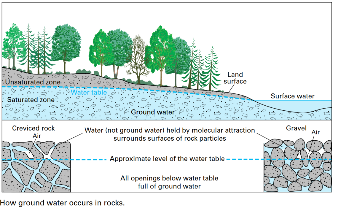
A combination of a place to put water (porosity) and the ability to move water (permeability) makes a good aquifer. Porosity is a measure of the open space in rocks –expressed as the percentage of open space that makes up the total volume of the rock or sediment material. Permeability is a measure of the interconnectedness of pores in a rock or sediment. The connections between pores allows for that material to transmit water. Porosity and permeability are functions of soil particle composition. For example, clays generally have very high porosity, but the pores are poorly connected, thereby causing low permeability.
Aquifers are commonly drilled, and wells installed, to provide water for agriculture and personal use. In many cases aquifers are being depleted faster than they are being replenished by water infiltrating down from above. Groundwater is a particularly important resource in arid climates, where surface water may be scarce. In addition, groundwater is the primary water source for rural homeowners, providing 98% of that water demand in the U.S.
As groundwater is pumped from water wells, there usually is a localized drop in the water table around the well called a cone of depression (figure \(\PageIndex{j}\)). When there are a large number of wells that have been pumping water for a long time, the regional water table can drop significantly. This is called groundwater mining, which can force the drilling of deeper, more expensive wells that commonly encounter more saline groundwater. Rivers, lakes, and artificial lakes (reservoirs) can also be depleted due to overuse. Some large rivers, such as the Colorado in the U.S. and Yellow in China, run dry in some years.
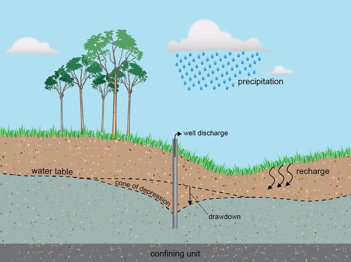
Another water resource problem associated with groundwater mining is saltwater intrusion, where overpumping of fresh water aquifers near ocean coastlines causes saltwater to enter freshwater zones. The drop of the water table around a cone of depression in an aquifer can change the direction of regional groundwater flow, which could send nearby pollution toward the pumping well instead of away from it. Finally, problems of subsidence (gradual sinking of the land surface over a large area) and sinkholes (rapid sinking of the land surface over a small area) can develop due to a drop in the water table. Because the pores in the aquifer collapse as subsidence occurs, this permanently reduces the capacity of the aquifer to hold water in the future.
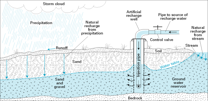
Groundwater is replenished through infiltration, seepage from surface water (lakes, rivers, reservoirs, and swamps), surface water deliberately pumped into the ground, irrigation, and underground wastewater treatment systems (septic tanks). Recharge areas are locations where surface water infiltrates the ground rather than running into rivers or evaporating (figure \(\PageIndex{k}\)). Recharge areas are generally the topographically highest location of an aquifer. They are characterized by streams that lie below the water table and sediment or rock that allows infiltration into the subsurface. Wetlands, for example, are excellent recharge areas. Recharge areas mark the beginning of groundwater flow paths.
Recharge can be induced through the aquifer management practice of aquifer storage and recovery. Injection wells allow for humans to increase the rate of recharge into an aquifer system by pumping water into an aquifer (figure \(\PageIndex{k}\)). Injection wells are regulated by state and federal governments to ensure that the injected water is not negatively impacting the quality or supply of the existing groundwater in the aquifer. Some aquifers are capable of storing significant quantities of water, allowing water managers to use the aquifer system like a surface reservoir. Water is stored in the aquifer during periods of low water demand and high water supply and later extracted during times of high water demand and low water supply.
Attributions
- Water Cycle and Fresh Water Supply, Water Supply Problems and Solutions, and Biogeochemical Cycles from Environmental Biology by Matthew R. Fisher (licensed under CC-BY)
- The Water Cycle, Water Use and Distribution, and Groundwater from An Introduction to Geology by Chris Johnson et al. (licensed under CC-BY-NC-SA)
- Biogeochemical Cycles and the Flow of Energy in the Earth System from Sustainability: A Comprehensive Foundation by Tom Theis and Jonathan Tomkin, Editors (licensed under CC-BY). Download for free at CNX.
- Biogeochemical Cycles from Biology 2e by OpenStax (CC-BY). Access for free at openstax.org.