
17.6: Prioritization - What Should be Protected?
- Page ID
- 71557

Historically, the boundaries of protected areas was often determined through pragmatic considerations, such as the availability of funds and land, and political influence, rather than ecological considerations. Many conservation areas were thus established on “lands that nobody wants”: marginal areas with little agriculture and development potential, or areas that were too remote to have high commercial value (a trend that continues even today: Venter et al., 2018). Other protected areas were established in locations with charismatic megafauna, so ecosystems without those species remained unprotected. Consequently, some of Earth's most threatened species and ecosystems remain under-protected (Beresford et al., 2011).
In a crowded world with finite natural resources and limited funding, it is increasingly important to be strategic about where protected areas are established.
In a crowded world with finite natural resources and limited funding, it is becoming increasingly important to be strategic about where protected areas are established. To do this, conservation biologists and policy makers must answer three key questions: (1) What is most important to protect? (2) Where would it be best protected? (3) How could it be most effectively protected? Three criteria can be used to answer the first two of these questions:
- Distinctiveness (or irreplaceability): Ecosystems with species that are distinct in their taxonomy (e.g. ecosystems that contain the only species in a taxonomic group) or geographic distribution (e.g. endemic species), or ecosystems with unique attributes (e.g. scenic landscapes, unusual geological features).
- Endangerment (or vulnerability): Areas that contain concentrations of species threatened with extinction, or ecosystems in danger of being destroyed.
- Utility: Species and ecosystems that people value, including culturally significant species, economically valuable species or ecosystems, or areas that can contribute to combating climate change.
Using these criteria, scientists have developed several broadly complementary methods to prioritize areas for protection. The approaches differ more in what traits they emphasize rather than in their fundamental principles. Thus, although some people may argue about which approach is better, each approach contributes to the protection of biodiversity.
Species approach
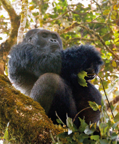
Many protected areas are created to protect (e.g. threatened, culturally significant, or keystone) species. Species that provide the motivation to establish a protected area are known as focal species. As a prominent example using the focal species concept, the Alliance for Zero Extinction (http://www.zeroextinction.org) identified 853 priority sites globally that contain the last remaining populations of one or more Endangered or Critically Endangered species. Flagship species, such as gorillas, are a special kind of focal species because they capture public attention, have symbolic value, and are important for ecotourism purposes. Many flagship species and focal species are also umbrella species, because their protection indirectly benefits other species and ecosystem components with which they share their landscape (Figure 17.6.1).
Ecosystem approach
There is debate among conservation biologists over whether ecosystems rather than individual species should be the primary target of conservation efforts. Supporters of an ecosystem approach argue that protecting and managing ecosystems can preserve more species and provide more value to people than spending the same amount of money to protect individual species. Focusing on ecosystems also allows for greater flexibility in justifying conservation efforts, because it can be easier to demonstrate the economic value of ecosystems for helping to control floods, filtering water, and providing opportunities for recreation. To that end, the WWF has identified 238 ecoregions across the globe (the “Global 200”) that are most crucial to the biodiversity conservation (Olson et al., 2002). This Global 200 analysis formed the basis of a more recent global assessment that identified 41 at-risk ecoregions—areas of high conservation priorities because they are undergoing high levels of habitat conversion and have low protected areas coverage (Watson et al., 2016). The IUCN Red List of Ecosystems (RLE) is another example of an ecosystem-focused prioritization for conservation. While the ecosystems approach overcomes several limitations of the species approach, some conservationists argue that focussing on distinct ecosystems may, in itself, be detrimental, and that the scope of conservation should be expanded, for example by also including biogeographic transition zones (van Rensburg et al., 2013).
Wilderness approach
Wilderness areas are large areas where people have had little influence on the environment (relative to other areas), they have few people living in them, and are unlikely places for human development in the short term. These areas are conservation priorities because they may be the only places where animals that require large home ranges can continue to survive in the wild. Further, wildernesses can serve as controls or benchmarks for researchers to measure the effect of human disturbance on nature. The most popular way to identify wilderness areas is to identify areas without roads. While very few roadless areas remain, many of the world’s most important roadless wildernesses, some larger than 10,000 km2, are in Africa (Ibisch et al., 2016). Of concern is that, second to South America, Africa also leads the world in wilderness losses over the past decade (Potapov et al., 2017). It is worth emphasizing that even wilderness areas have had a long history of human activity (Roberts et al., 2017). It is not always necessary or even possible to eliminate all human activity from such areas, if those activities do not obstruct conservation goals.
Hotspot approach
Multiple prominent initiatives have prioritized conservation in areas where large concentrations of species can be protected in a relatively small area. Perhaps the most prominent example is the Global Biodiversity Hotspots initiative. Combining a species approach with an ecosystem approach, Global Biodiversity Hotspots are areas with exceptionally high levels of biological diversity and endemism—that is, irreplaceable biodiversity—that are threatened with imminent habitat destruction. Conservation International (CI) has identified an expanded set of 36 Biodiversity Hotspots (Mittermeier et al., 2005). This expanded set of Biodiversity Hotspots covers only 2.3% of Earth’s surface yet contains over 50% of all plant species and over 40% of all terrestrial vertebrate species.
https://www.cepf.net/our-work/biodiversity-hotspots.
While the Global Biodiversity Hotspots highlight some of the most important global conservation priorities, none of these Hotspots are small enough to be contained in a single protected area—in fact, most of these Hotspots identify whole regions, not projects, requiring conservationists to still make decisions for prioritizing protection within them. To create actionable priorities from within regional hotspots, several initiatives aim to identify local hotspots of species richness that can be conserved as one protected area of a manageable size. One such approach is the Key Biodiversity Areas (KBA) program (Eken et al., 2004), which identifies conservation priorities using standardized criteria and thresholds that account for concentrations of threatened species and/or globally significant population aggregations. The KBA program functions as an umbrella designation for several taxon-specific approaches, most prominently BirdLife International’s Important Bird and Biodiversity Areas (IBA) program (Fishpool and Evans, 2011). Other KBA programs include PlantLife International’s Important Plant Areas program (e.g. Smith and Smith 2004), as well as the Important Sites for Freshwater Biodiversity program (Darwall et al., 2005).
Gap analysis approach
Assessing the performance of existing protected areas can be done by spatially comparing their footprint to prioritized conservation areas (as above). Such an assessment offers not only an assessment of existing protected areas performance, but also offers a means to identify conservation gaps—important areas that still need to be protected to meet broader conservation goals. Such assessments, which systematically evaluate whether different aspects of biodiversity are adequately protected, are collectively known as systematic conservation planning assessments (McIntosh et al., 2017). Perhaps the most popular systematic conservation planning method is gap analysis, during which scientists overlay maps of species (or ecosystem) distributions with maps of protected areas to identify species (called gap species) or ecosystems that are not adequately protected in existing protected areas networks (Box 17.6.1).
When identifying conservation gaps, it is important to think carefully about the taxa or ecosystem used to make the assessment. Many conservation assessments assume that one well-known species group can act as a biodiversity indicator (also known as a biodiversity surrogate or surrogate species) for lesser-known taxa, so establishing a protected area to protect one gap species will also afford protection to other under-protected taxa. While this is true to some level, several studies have shown that this may not always be the case (Rodrigues and Brooks, 2007; Carwardine et al., 2008; Jones et al., 2016).
Gap analysis enables conservation planners to identify species or ecosystems that are not adequately protected in existing protected areas networks.
Andrew J. Plumptre12
1Albertine Rift Program,
Wildlife Conservation Society, Kampala, Uganda.
2Current Address:
Key Biodiversity Area Secretariat,
c/o BirdLife International, Cambridge, UK.
aplumptre@keybiodiversityareas.org
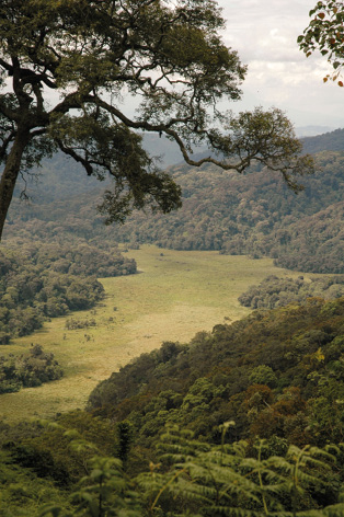
The Albertine Rift is one of the richest regions on Earth for vertebrate diversity (Figure 17.6.1). Spanning about 100 km either side of the international border of the eastern DRC, it includes forests, wetlands and savannahs from eastern DRC and western Uganda, Rwanda, Burundi, and Tanzania, and runs from the northern end of Lake Albert to the southern end of Lake Tanganyika. It contains more than 40% of Africa’s mammals, 52% of Africa’s birds, as well as 19% of its amphibians and plants, in only 1% of the continent’s surface area. It also contains more endemic and globally threatened species than any other ecoregion in Africa (Plumptre et al., 2007). Endemic large charismatic species include the eastern gorilla (Gorilla beringei, CR), golden monkey (Cercopithecus kandti, EN), Congo bay owl (Phodilus prigoginei, EN), and Ruwenzori turaco (Ruwenzorornis johnstoni, LC). The lakes in the Albertine Rift each also contain several hundred unique fish species. Unfortunately, this rich biodiversity also occurs in one of the most densely populated parts of Africa, and the threats to existing protected areas are high.
The Wildlife Conservation Society (WCS) has been working to support the conservation of six key landscapes in the Albertine Rift (ARCOS, 2004), particularly focusing on (a) identifying critical areas for conservation of threatened and endemic species; (b) undertaking research and monitoring of species and key landscapes; and (c) supporting the conservation of critical sites and the creation of new protected areas to conserve large and small mammals, birds, reptiles, amphibians and plants in all protected areas, as well as sites where new protected areas might be established. These surveys have identified critically important areas in eastern DRC, such as the Itombwe and Kabobo Massifs where new species have been identified and some species were rediscovered, having been last seen more than 50 years ago. Working with local communities, the surveys have been used to design the boundaries of newly established protected areas to ensure that they capture as much of the biodiversity as feasible. Once the local people in the area are presented with survey results and options for protection discussed, they often realize the importance of their site and propose more stringent protection measures than conservationists initially thought possible.
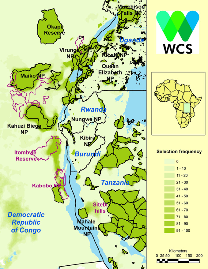
Using species distribution models (SDM) of the region’s endemic and globally threatened species, WCS gained an understanding of where these species should occur both now and under future climate change scenarios (Ayebare et al., 2018). Using Marxan software (Possingham et al., 2000), WCS then identified those areas that would conserve all the species of conservation interest at minimum cost (Plumptre et al., 2019). This procedure identified the Itombwe and Kabobo Massifs together with the Sitebi Hills east of Mahale Mountains National Park in western Tanzania as being critical for conservation of species that are currently not adequately protected (Figure 17.6.2).
These results were used to develop an Albertine Rift Action Plan (Plumptre et al., 2016), together with detailed conservation action plans for the preservation of the six core landscapes and their unique and threatened species, both inside and outside of protected areas, now and into future.